Subject: Lima, Peru
Period: 1688 (published)
Publication: La Estrella de Lima Convertida en Sol
Color: Black & White
Size:
20.4 x 14.5 inches
51.8 x 36.8 cm
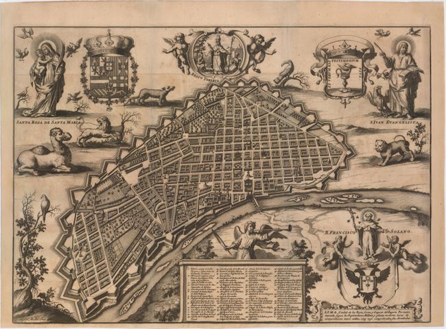
After Mexico City, Lima was the second-most important city in the Hispanic New World. Spaniards first began to settle in Lima at the end of 1534, and Francisco Pizarro officially named the native village "Lima, la Ciudad de los Reyes" on January 18, 1535. In 1543 the Spanish crown declared Lima the capital of the Viceroyalty of Peru, and the following year it was designated as an audiencia (high court), both of which helped to populate and grow the city with merchants, officials, lawyers, and other high-society Spaniards. As Lima and its port at Callao became a standard stopping-point for trade along the Pacific coast, they were vulnerable to numerous attacks by pirates and English and Dutch navigators, including Francis Drake and Joris van Spilbergen. As a result, the Viceroy of Peru, Don Melchor de Navarra y Rocafull, built walls and around Lima in 1687. Shortly thereafter the city suffered a devastating earthquake, killing hundreds and leveling much of the city and new walls.
In conjunction with the building of the walls, Juan Ramon Koninick, a Flemish Jesuit, was appointed to draw an official plan of the city. He completed his manuscript map in 1685, which depicted the city's symmetrical streets, numerous churches, and various districts. Koninick's plan was used as the source for the first printed plan of Lima, published in Francisco de Echave y Assu's "La Estrella de Lima Convertida en Sol" in Antwerp in 1688. Echave's work was created to record the festivities regarding the beatification of Saint Toribio Alfonso de Mogrovejo, the second Archbishop of Lima, by Pope Innocent XI in 1679. The work also included a thorough description of Lima and an ecclesiastical history of the diocese.
Echave's plan exaggerated the regularity of the city's blocks and the size of the churches, the latter of which was meant to demonstrate the piety of Lima's citizens. Surrounding the plan are further religious symbols, including portraits of Saints from Lima: Mogrovejo, Rose, and Francis Solanus. Echave wanted Lima to be seen as a "western paradise," and therefore incorporated exotic animals into the plan, such as a camel, a lion, an armadillo, a toucan, and a puma. The plan also includes a key to 61 locations and the town's coat of arms held aloft by putti. Engraved by Joseph Mulder. As Echave's plan was the first printed plan of Lima, it became the foundation map for the city and was copied by numerous others throughout Europe.
References:
Condition: B+
A dark impression, issued folding and now pressed with a few short fold separations that have been professionally repaired. There is light toning and offsetting, and the map has been remargined at right and left to accommodate framing, with a small amount of neatline replaced in facsimile.