Subject: Rio de Janeiro, Brazil
Period: 1750 (circa)
Publication:
Color: Hand Color
Size:
11.9 x 8.4 inches
30.2 x 21.3 cm
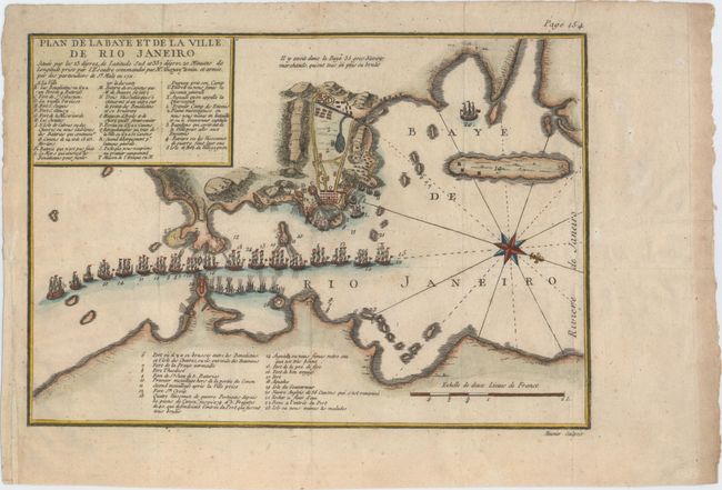
This handsome bird's-eye plan of Rio de Janeiro and Guanabara Bay was created to illustrate the French siege of 1711. A large compass rose orients north to the right. Lettered and numbered keys identify various ships and important locations, including islands, forts, magazines, and batteries. Engraved by Meunier.
This map was first published in Memoires de Monsieur du Guay-Trouin in 1740, with two later editions of the map published as late as 1785. Rene Duguay-Trouin was a French pirate from Saint-Malo who later became Lieutenant General of the French Royal Navy. In 1711, during the War of Spanish Succession, Duguay-Trouin led seventeen ships and 6,000 men to Guanabara Bay to capture Rio de Janeiro. The French were successful in defeating the Portuguese and overtook the city. After occupying the city for two months, the French received word that Portuguese reinforcements were being sent under the command of Antonio de Albuquerque. Duguay-Trouin decided to return to France, first securing a loot of an estimated 4 million pounds from the gold supply of the city. All editions of this map are very rare.
References:
Condition: A
A dark impression on watermarked paper with attractive color. Issued folding with a minor paper repair in left blank margin.