Subject: Richmond, Virginia, Civil War
Period: 1864 (circa)
Publication:
Color: Black & White
Size:
16.5 x 27 inches
41.9 x 68.6 cm
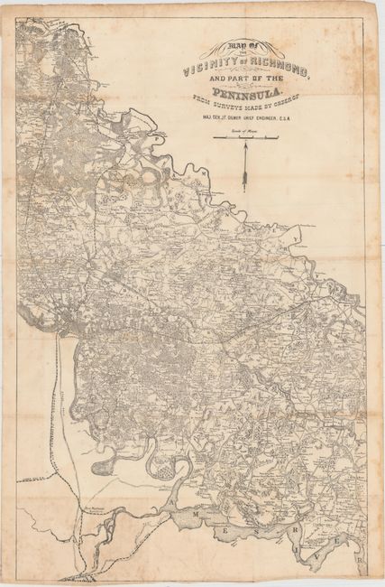
This scarce map is a smaller variant of the Campbell map (Map of the Vicinity of Richmond and Part of the Peninsula), of which the sole known example resides in the Hargett Library at the University of Georgia. The Campbell map and this Gilmer version include a backwards N and S in the north arrow. The map shows the region bounded on the north by Hanover Junction and the North Anna River, on the east by the Pamunkey River and in the south by the James River well below Richmond. The map extends with less detail to Petersburg. Locates hundreds of individual land holdings each identified by name, wagon roads and tails, churches, and much more. The railroads named are the City Point, Clover Hill, Richmond and Petersburg, and three other unnamed rails originating from Richmond and traveling north and east. In all a remarkably detailed campaign map that is drawn on a scale of about 1.6 miles per inch.
The map was surveyed and drawn under the direction of Jeremy Francis Gilmer, Chief Engineer, C.S.A. Gilmer had been a United States Army Engineer from 1839 until the beginning of the conflict when he entered the Confederate Army. He was appointed Major of Engineers and eventually reached the rank of Major General. After the war, he was a director for the Georgia Central Railroad and then president of the Savannah Gas-Light Company.
References: cf. Stephenson (CW) #624.
Condition: B
Issued folding with scattered foxing and some dampstaining confined to the right blank margin.