Subject: California
Period: 1862 (dated)
Publication:
Color: Black & White
Size:
28.3 x 38.5 inches
71.9 x 97.8 cm
The Office of Coast Survey is the oldest U.S. scientific organization, dating from 1807 when Congress directed that a "survey of the coast" be carried out. By 1836, it was called the U.S. Coast Survey and in 1878, the name was changed to the U.S. Coast and Geodetic Survey. Today the Office of Coast Survey is a division of the National Oceanic and Atmospheric Administration NOAA.
The survey teams, composed of civilians as well as Army and Naval officers, charted the nation's waterways and produced a wide array of reports, survey charts, hydrographic studies of tides and currents, astronomical studies and observations, and coastal pilots. These charts are an important record of the changing nature of the nation's coastlines. In additional to coastal charts, the U.S. Coast and Geodetic Survey produced land sketches, Civil War battle maps, and the early aeronautical charts.
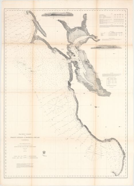
This large and detailed chart extends from Monterey Bay north to Bodega Bay, including all of San Francisco and San Pablo bays, and north to Petaluma. It is filled with information including soundings, light houses, islands, and remarkable coastline detail. Two views from Noonday Rock are also featured. Cities of Oakland, Vallejo, Benicia, Brooklyn, Union City, Redwood City, and more are located. This map provides a terrific view of the development of the region around San Francisco a little more than a decade after the start of the Gold Rush.
References:
Condition: B
Issued folding with light toning along the folds, minor scattered foxing, and some fold separations that have been closed with archival tape.