Subject: Southern Asia
Period: 1595 (circa)
Publication: Itinerario…
Color: Black & White
Size:
20.9 x 15.2 inches
53.1 x 38.6 cm
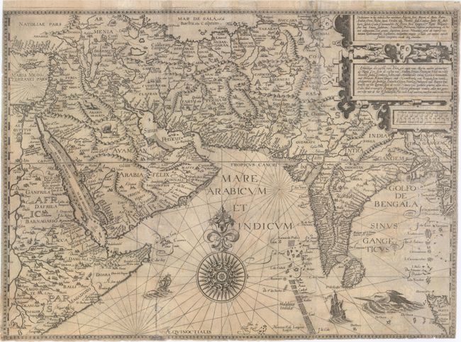
This decorative map of southern Asia is considered one of the first detailed navigational charts of the Indian Ocean and Arabian Sea. The map extends east to include Cyprus and eastern Africa, north to the Caspian Sea, and east to Bangladesh and part of Burma. The Caspian Sea is depicted stretching in an east-west orientation, and there are several spurious mountain ranges. Although partially based on Giacomo Gastaldi's map for the interior regions, Henricus Langren also used portolan charts to refine coastal detail. In addition, the Indian subcontinent was based on Linschoten's experience living in India for 13 years, and resulted in a much more accurate shape than shown on previous maps by Ortelius and Mercator. The Arabian peninsula is also depicted more accurately than previously, although there is little interior detail, and numerous inaccuracies, including a large gulf where Jeddah should appear, which is named three ways: Gidda, Ziden, and Juda. This map is believed to be the first to use the names Babelmandel (now Bab el-Mandeb) for the strait at the southern tip of the Red Sea and Mare Arabicum for the Arabian Sea. The map was beautifully engraved by Langren and is richly adorned with a large compass rose, sea monsters, sailing vessels, and a number of animals, including a pair of unicorns in the interior of India.
References: Ankary, pp. 74-76 & 148-49; Tibbetts #46; Shirley (BL Atlases) G.LIN-1a #3.
Condition: B
A nice impression issued folding with some light stains and soiling. There are some short separations and tiny holes along the folds, as well as some tiny tears, the majority of which have been archivally repaired, and resulting in very minute loss of image to the left of the title cartouche. There is an abrasion southwest of the compass rose, with a small amount of rhumb lines replaced in facsimile. Trimmed to neatlines at right, left and bottom.