Subject: Southeast Asia
Period: 1676 (published)
Publication: A Prospect of the Most Famous Parts of the World
Color: Hand Color
Size:
19.8 x 15 inches
50.3 x 38.1 cm
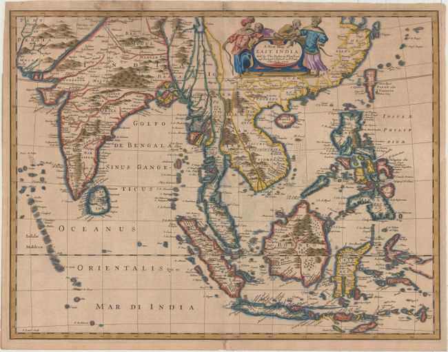
This handsome map of Southeast Asia, based on Frederick de Wit's map of 1662, was engraved by Francis Lamb for the last edition of John Speed's popular world atlas. The map covers from southeastern Persia to Formosa (Taiwan), the Philippines, and Indonesia. The map illustrates the region in which the Dutch East India Company (VOC) had built a great trading empire in the seventeenth century; a region over which the English sought to gain control. Much of the information is very generalized due to Dutch secrecy about the region. The great rivers of Southeast Asia are not shown, and all except the Mekong are shown as having their source in the mythical Lake Chiamay in China. A prominent feature in northern India is the royal road of the Moguls between Agra to Lahore, shown as a broad tree-lined route. The verso contains a description of India in English text. Published by Bassett and Chiswell.
References: Parry (SEA) plt. 5.3, pp135-36; Moreland & Bannister, p.273; Shirley (BL Atlases) T.SPE-2f #27.
Condition: B+
A dark impression on watermarked paper with toning and very short centerfold separations at top and bottom that have been repaired. There are two tiny tears in the top blank margin that have also been repaired.