Subject: Northern Colombia
Period: 1970 (dated)
Publication:
Color: Hand Color
Size:
33.2 x 18.7 inches
84.3 x 47.5 cm
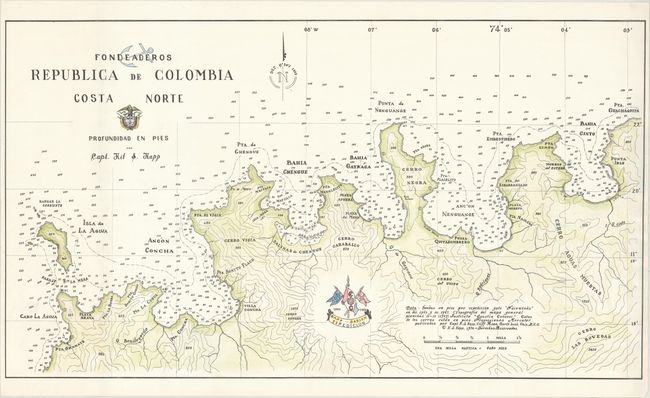
This lovely navigational chart depicts the northern coast of Colombia just northeast of the city of Santa Marta. The chart gives excellent detail of the bays and points in the area, with soundings, rocks, shoals, and anchorages carefully noted. The navigational information is based on measurements taken by Captain Kit S. Kapp during several expeditions on his yacht, Fairwinds, between 1963-67. The only details noted inland are the courses and names of rivers and the topography of the land, with elevations noted. The topographical details are based on a 1959 survey by the Geographic Institute Agustin Codazzi, an entity of the Colombian government.
Captain Kit S. Kapp was a ship captain who explored the Caribbean, Central America, and northern South America. Kapp collected many things during his lifetime, and his favorite collection was of antique maps. He eventually turned his map collection into a business, buying and selling maps all over the world. Kapp's love of maps also led him to become a cartographer and he published 8 sailing charts of the waters around Honduras, Panama, Colombia, Venezuela, and the British Virgin Islands. To read the full story of Captain Kapp's life, please read the article from our January newsletter.
All proceeds from the sale of this map will be donated to the International Map Collector's Society (IMCOS) in honor of Captain Kit S. Kapp.
References:
Condition: A
Clean and bright with an extraneous vertical crease at left. Original hand coloring by Kit Kapp himself.