Subject: Virginia, West Virginia, Civil War
Period: 1867 (dated)
Publication:
Color: Printed Color
Size:
33.4 x 21.3 inches
84.8 x 54.1 cm
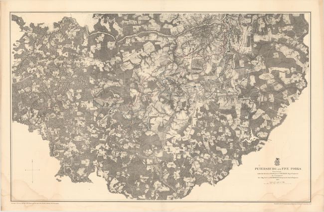
A. Petersburg and Five Forks from Surveys Under the Direction of Bvt. Brig. Gen. N. Michler…. This is a detailed topographic map with the Appomattox River in the north, Petersburg in the upper right, and Five Forks at the far left center. Confederate works are shown in red and Union fortifications in blue. Houses, names of residents, railroads, roads and the street pattern of Petersburg are among the features shown. The Battle of Five Forks was fought on April 1, 1865, southwest of Petersburg in Dinwiddie County. The battle, sometimes referred to as the "Waterloo of the Confederacy," pitted Union Major General Philip H. Sheridan against Confederate Major General George E. Pickett. Lee ordered Pickett to hold the crossroads of Five Forks with his infantry division and three cavalry divisions. Pickett's loss at Five Forks triggered Lee's decision to abandon Petersburg and begin the retreat that led to his surrender at Appomattox Court House on April 9th. Ref: Stephenson #607.9; Phillips (A) #3688-11. Condition: There are faint damp stains in the bottom corners of the sheet that enter the border. (B+)
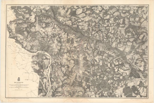
B. Richmond… Very detailed map of the vicinity of Richmond and eastward about 16 miles to include all battle lines in color. Shows common roads, railroads, and fortifications (Union in blue; Confederate in red). Richmond and Manchester are shown with street detail with a ring of heavy fortifications surrounding both. Ref: Stephenson #632.8; Phillips [A] Vol. 3 #3688-9. Condition: There is a little toning in the image, a crease at far left, a few damp stains confined to the lower blank margin, and an edge tear at right that just enters the border closed on verso with archival tape. (B+)
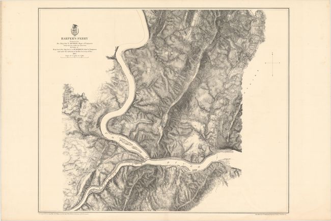
C. Harper's Ferry… The skillful use of hachure dramatizes the terrain at the intersection of the Potomac and Shenandoah Rivers at Harpers Ferry, West Virginia. The map is centered on Fort Duncan and Stone Fort which are printed in blue indicating the area was in Union control. The map identifies residents, railroads, roads and terrain features. Ref: Stephenson #697.6. Condition: On a clean, bright sheet. (A+)
References:
Condition:
See description above.