Subject: Central United States
Period: 1843 (published)
Publication:
Color: Hand Color
Size:
32 x 23 inches
81.3 x 58.4 cm
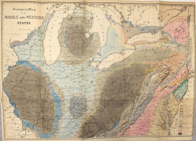
This colorful lithographed geological map, produced by the eminent American geologist James Hall, blends science and the art of cartography. Twenty-three geological types are named and differentiated using hand applied color. The map covers the region of the United States from its western boundary along the Mississippi River, east to Long Island and the Atlantic. It includes all or parts of Wisconsin, Illinois, Missouri, Kentucky, Virginia, Indiana, Ohio, Michigan, Pennsylvania, New York, New Jersey, Maryland, and Delaware. The lakes Michigan, Huron, Erie and Ontario are shown. Lithographed by Endicott of New York and signed in the plate by James Hall. It employs the "New York System" of stratigraphic nomenclature developed by Hall and others at the New York Geological Survey. This system emphasized the importance of paleontology for delineating geological units and introduced the concept of "type locality," a primary reference location used for defining the characteristics of geological formations. This map is the first regional application of this new system, which evolved into the standard nomenclature used today for North America and much of the rest of the world.
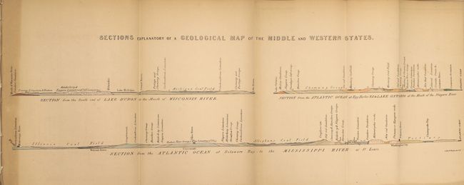
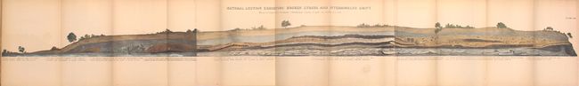
The map is bound into the 683 page report, including 34 plates of tables with figure drawings of fossils; 24 lithographed plates of views, profiles and sections, including 4 b&w (3 folding), 8 tinted views, 12 folding, hand colored geologic profiles and the large, folding hand colored geologic map of the middle and western states. In original brown cloth with gilt illustration on front cover.
References: Marcou #32.
Condition: B+
Condition code is for the large map which is clean with minor toning, most noticeably in the top right corner where the map folds into the book. Other text and plates are very good to near fine with light toning on a few. Covers are intact and show the typical shelf wear, but spine is missing.