Subject: World
Period: 1640 (published)
Publication: Speculum Solis…
Color: Black & White
Size:
14.3 x 11.3 inches
36.3 x 28.7 cm
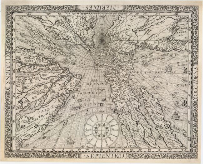
A rare and extremely unusual map shows the world projected from the North Pole as if it were the table of a sundial. Although at first glance it appears as if the landmasses are melting off the earth, they are actually drawn to scale based on a mathematical projection that links time and location. Ritter uses a gnomonic projection, in which surface points of a sphere are projected from the center of the earth onto a tangent plane. Meridians and the Equator are shown as straight lines, while all other parallels are depicted as ellipsis, parabolas or hyperbolas. In order to use the map to tell time, the center point would be 45°N 10°E, from which point a shadow would be cast onto a meridian to indicate the local sun time. The gnomonic projection was originally called horologium due to its relationship to sundials.
The result is a very distorted, though mathematically correct, projection, with the distortion increasing rapidly away from the center point. The geography on the map is limited to major rivers, mountain ranges, and a few place names, primarily along the coasts. Virginia and Florida are noted in North America, and the fabled golden city of Manoa appears on the mythical Parime Lacus in South America. The map is filled with engravings of animals, sea monsters, ships, and a few bizarre characters, such as a pair of headless humans, and is surrounded by a floral border. This is the second state.
References: Shirley #270.
Condition: A
Fine impression with faint soiling in borders. Blank margins have been professionally remargined with a bit of very skilled facsimile in the border at left.