Subject: Northern Asia
Period: 1685 (circa)
Publication: Noord en Oost Tartarye
Color: Black & White
Size:
7.3 x 5.6 inches
18.5 x 14.2 cm
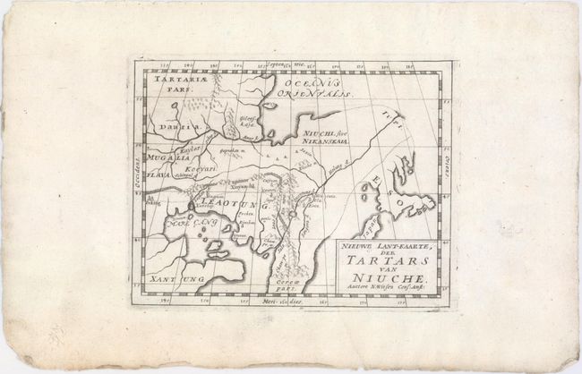
This fascinating map of northeastern Asia by Nicolaas Witsen shows numerous geographical misconceptions. Although Korea is correctly shown as a peninsula, there are conjectural dotted lines connecting it to Eso (Hokkaido). The Amur River is shown flowing west, rather than south-southwest, with its mouth in the Sea of Okhotsk (Oceanus Orientalis), rather than in the narrow Strait of Tartary, which divides the Russian mainland from the island of Sakahlin. In China, the Great Wall is prominently depicted and several cities are named. Peking is shown at 44 degrees latitude, despite the fact that the Jesuits had correctly measured it at 40 degrees latitude. Although Witsen was aware of this discovery, he chose instead to use the figure determined by Dutch Jesuit Father Verbiest, who had calculated the latitude and brought his findings to Witsen. As a result, many of the remaining cities noted are also miscalculated by 4-7 degrees. (However in Witsen's similar map of the region, Peking is correctly depicted at 44 degrees latitude. See lot 620.)
Nicholaas Witsen (1641-1717) was a Dutch statesman, administrator of the VOC, and cartographer. After studying Russia for over 20 years, Witsen became the first to publish a comprehensive work on Siberia and the Far East, Noord en Oost Tartarye, first published in 1685. There were several editions, often containing updated maps. This map appeared in the first edition as well as at least one 18th century edition.
References:
Condition: A
A nice impression on watermarked paper with wide margins.