Subject: Western Europe
Period: 1876 (dated)
Publication:
Color: Black & White
Size:
72.9 x 40.2 inches
185.2 x 102.1 cm
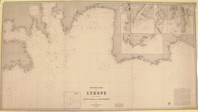
This massive blue-backed chart is on three joined sheets. It covers the area from southern Ireland and Great Britain through the English Channel, the Bay of Biscay, Spain, Portugal and across the Strait of Gibraltar to Morocco. Anchorages, compasses, soundings, bottom types, lighthouses (marked in red and yellow), currents and more are shown. The coasts feature plenty of place names and good topographical detail. There are ten insets providing more detailed views of various locales along the coasts: Plateau de Rochebonne, St. Martin de la Arena (Requejada), Castro Urdiales, Entrance to the River Gironde, Cape Finisterre &c., Santander, Setuval, Entrance to the River Douro, Burling I. &c., and Entrance to the River Tagus. A note at bottom explains the abbreviations used, and a lengthier note titled "General Remarks" discusses the Rennel and Portuguese currents.
References:
Condition: B+
A nice impression with original color (red and yellow) on lighthouses. There are abrasions in the St. Martin inset, light soiling, a small chip in the top left corner, and a short edge tear that just enters the neatline at right. A few manuscript notations in pencil also appear.