Subject: Grenada
Period: 1778 (dated)
Publication: Pilot Americain 2.e Partie
Color: Black & White
Size:
23.8 x 17.9 inches
60.5 x 45.5 cm
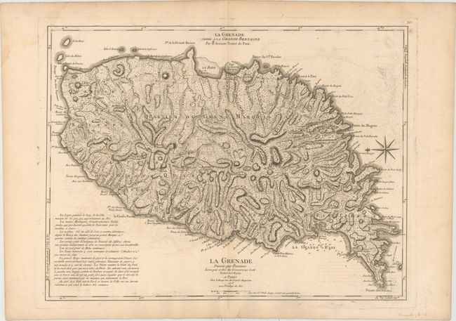
Handsome and hard to find map of the island shows the topography by use of hachure along with roads, towns, hospitals, and plantations. A note at bottom left describes the attributes of the land and notes the fifty paces along the coast belonging to the King of England. Grenada had passed back and forth between the British and French colonial powers during the 18th century, with France ceding the island to Britain in the 1763 Treaty of Paris. The French regained control during the American battle for independence, and won the island during the 1779 Battle of Grenada. In 1783, the island was ceded back to the British with the Treaty of Versailles. The coastlines are well delineated and include the locations of safe harbor and soundings in the bays. The map has a striking compass rose orienting the map with north to the left. The map is based on Thomas Jefferys' map of the island, first published in 1775. Second French title at top: La Grenade Cedee a la Grande Bretagne par le Dernier Traite de Paix.
References: Tooley (MCC-62) Grenada #32; Shirley (BL Atlases) M.LER-2a [30].
Condition: B+
Watermarked paper with light offsetting and a faint damp stain at top left, just entering neatline at top corner.