Subject: Ohio
Period: 1812 (circa)
Publication: Travels in the United States...
Color: Black & White
Size:
9.6 x 9.5 inches
24.4 x 24.1 cm
By the time of the Revolutionary War, the practice of awarding bounty land as an inducement for enlisting in the military had been a long-standing practice in colonial North America. Besides imperial bounty land grants, both colonial and municipal governments routinely compensated participants in and victims of military conflicts with land. Land was a commodity in generous supply, and governments seized upon its availability for accomplishing their goals.
Following this tradition, the Revolutionary governments used bounty land grants in their struggle for independence from Great Britain. They generally offered free lands in exchange for military service, provided they were victorious in their struggle. Thus, bounty lands were an effective technique for enrolling support for the war and encouraging re-enlistments. Generally the bounty lands were located on the western frontier, which provided another benefit to the government. Populating the frontier with citizens skilled in defense offered the best prospect in enticing other settlers to join them, thus eventually increasing the tax rolls.
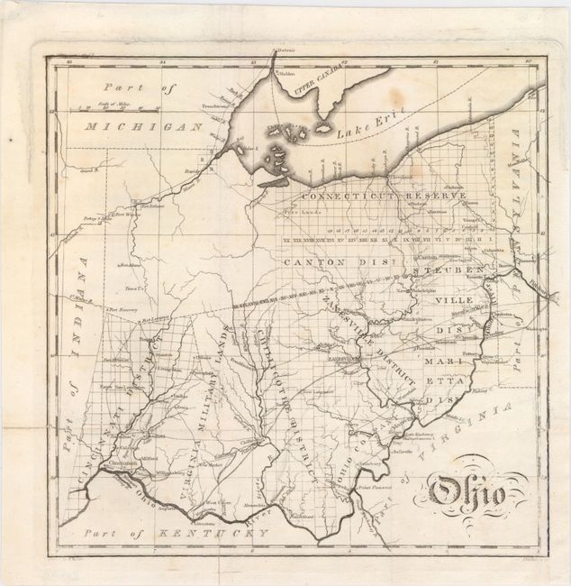
This uncommon, early map of Ohio details towns and villages, watershed and wagon roads. It depicts the extent of surveying that had taken place in the state, mostly in the eastern half, under the terms of the Land Act of 1804. The map displays five land districts as well as bounty land grants of Virginia Military District, the Ohio Company, and the rarely seen Connecticut Reserve. Engraved by John Vallance.
John Melish was the first American publisher to concentrate on cartographic and geographic publications. Born in Scotland, Melish immigrated to Philadelphia in 1811. In 1812 he published Travels in the United States of America, which included his first maps. He soon came to dominate the industry in this country, and had a huge impact on all subsequent American map-making.
References:
Condition: B+
Issued folding with a few faint spots and short fold separations closed on verso with archival material.