Subject: New York City, New York
Period: 1796 (dated)
Publication:
Color: Hand Color
Size:
21.5 x 12.4 inches
54.6 x 31.5 cm
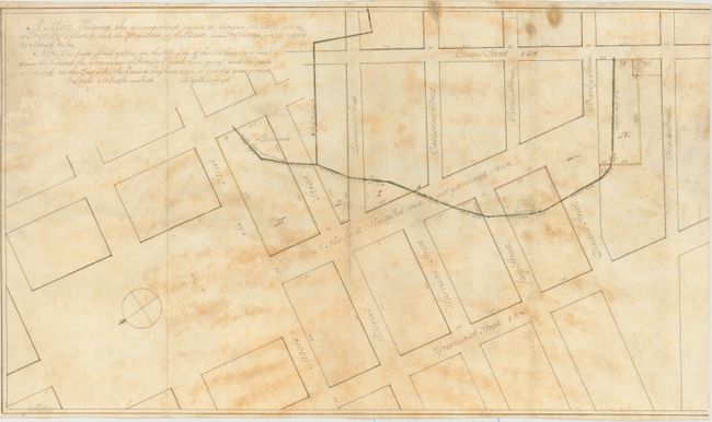
This fascinating and early manuscript survey map shows a portion of the Tribeca district in Lower Manhattan. The map is oriented with north to the southwest, and is bounded by Greenwich Street in the west, West Broadway (here called Chapel Street) in the east, Reade Street in the south, and Moore Street in the north. The street running through the middle of the map is Hudson Street, and is noted on the map as: "A new street ninety feet wide, not yet named." A number of other streets are named, including Duane, Barley (now Duane), Thomas, Catherine (now Worth), Leonard, Provost (now Franklin), Harrison, and Jay Streets. The map depicts the transfer of land between the Corporation of Trinity Church and the "Estate of Ireland," with the green line representing the boundary between the two parties. The areas marked on the map in yellow represent lands that the Trinity Church relinquished, and the areas marked in red represent the lands that the Trinity Church gained.
The Trinity Church was created by the Church of England community through a land grant approved by Governor Benjamin Fletcher in 1696. In 1705, Anne, Queen of Great Britain, granted the church additional land, increasing the parish's total land holdings to 215 acres. Over the years, Trinity Church has sold much of its land grants, although today it still holds 14 acres of real estate in Manhattan, making it one of the largest landowners in the city.
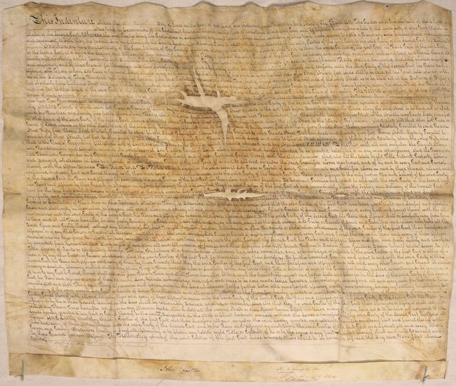
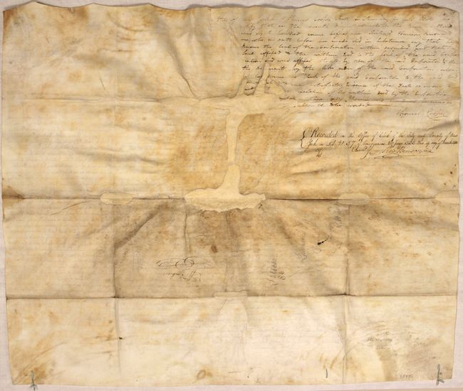
The map was drawn in May 1796 by Benjamin Taylor, an important surveyor who conducted numerous surveys throughout New York City. The map is accompanied by the original indenture outlining the agreement, signed on June 30, 1796. The indenture is written between the Protestant Episcopal Church of New York and Effingham Embree, a celebrated clock and watchmaker. The two parties agreed to establish a new boundary line between their properties that would be "more agreeable and convenient than the present line." Embree would also owe 10 pounds to the Trinity Church. The indenture is witnessed by John Charlton and Richard Harrison, an official of Trinity Church, and also signed by Thomas Cooper and Robert Benson. Indenture measures 25.9 x 21.7".
This is an important piece of the history of New York City, and would be a unique addition to any Manhattan collection.
References:
Condition: B
Map is in very good condition with some toning. The indenture has moderate toning, light soiling, and has been professionally conserved to repair two holes in the text, with some loss of text.