Subject: United States, Texas
Period: 1845 (dated)
Publication:
Color: Hand Color
Size:
21.5 x 15 inches
54.6 x 38.1 cm
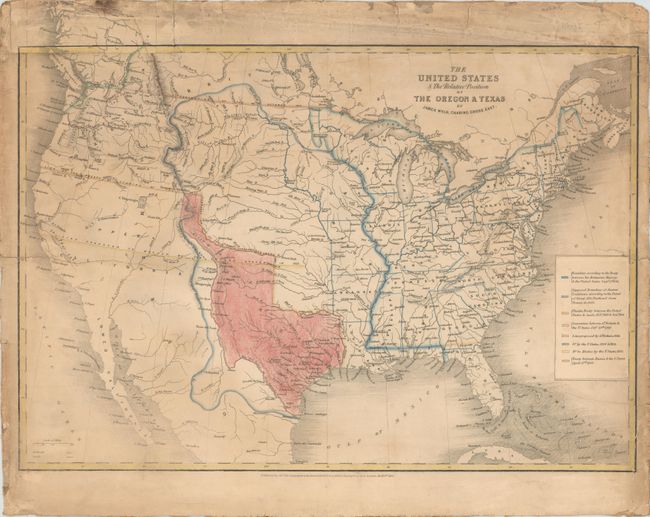
The United States and Great Britain established in 1818 joint claim over the Oregon Territory - the region north of Spanish controlled Upper California up to the southern boundary of Russia's Alaska Territory at North latitude 54°40'. By the late 1830's this arrangement was beginning to fall apart.
In the 1840's the expansionist Democrats, including their 1844 presidential candidate, James Polk, claimed the entire region for the United States. Their expansionist desires were expressed by Polk's famous campaign slogan, "Fifty-four Forty or Fight!" The slogan also became a rally cry for Americans desiring to settle the territory. Following Polk's election, the dispute was resolved by the 1846 Treaty of Oregon, which struck a compromise that fixed the U.S./Canadian boundary at 49º North.
This interesting map depicts the United States in the midst of dramatic westward expansion, just after the annexation of Texas and just prior to the Mexican-American War. The map shows several previous and proposed western boundaries. In the Pacific Northwest there is the Line Proposed by the Convention of the 20th October 1818, the Line Proposed by the Americans in 1824 & 1826, and the Line Proposed by the English in 1826. This region was still in dispute at the time this map was published. The Line of the Treaty of Florida of the 22nd February 1819 and of 12th January 1828 forms the U.S. boundary with Mexico and the northern border of Texas. The Line Proposed to Mexico by the United Sates in 1835 shows an obscure proposed boundary roughly on the 37th parallel. Texas is shown in its largest configuration with the panhandle elongated to include the panhandle of present-day Oklahoma, and parts of New Mexico and Colorado.
References: Wheat #503.
Condition: C+
Mounted on linen to reinforce and repair two 5" edge tears with a 5" x 2" section along and above the top left border that has been replaced with another example of the map. There is light soiling and several additional edge tears that are mostly confined to the blank margins.