Subject: Northern South America and Caribbean
Period: 1810 (dated)
Publication:
Color: Black & White
Size:
37.8 x 25.5 inches
96 x 64.8 cm
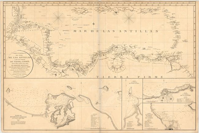
This large-scale chart depicts the coastlines surrounding the Caribbean Sea, extending from Belize to Venezuela and including the Caribbean islands from Jamaica through the Lesser Antilles. Hundreds of capes, points, rivers, and other place names are noted along the coasts, with depth soundings, rocks and shoals filling the coastal waters. Below the map are insets of four important Venezuelan ports: Puerto Cabello, Barcelona, La Guaira, and Cumana. Each inset includes extensive soundings, a key to the type of material found on the ocean floor in various locations, and a lettered key identifying points of interest. This is a very uncommon sea chart created by Jose de Espinosa y Tello de Portugal, an officer in the Spanish Royal Navy and Director of the Hydrographic Office in Madrid.
References:
Condition: B
A dark impression with some offsetting, light toning along centerfold and top edge of sheet, and a centerfold separation that enters 1" into map at bottom. There is an archivally repaired tear that enters 1.5" into a blank area of Puerto Cabello inset at bottom. There is a pale blue shadow along the centerfold that is caused by our scanner and does not appear on the map itself.