Subject: Eastern United States
Period: 1787 (published)
Publication: Lettres d'un Cultivateur Americain
Color: Black & White
Size:
25.8 x 18.9 inches
65.5 x 48 cm
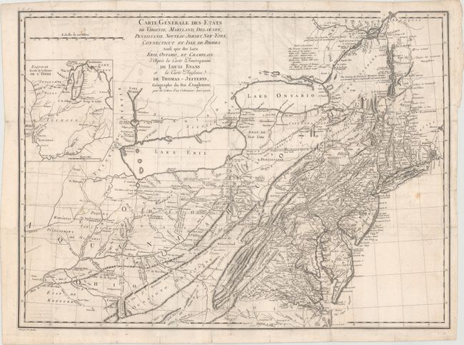
This is an updated French edition of Evans' rare and important map of the Middle Colonies that was first published in 1755. It was produced for St. John de Crevecoeur's book and includes some additions in New England, but fewer than the extensive additions of Pownall's 1776 reissue, according to McCorkle. Engraved by Pierre Francois Tardieu.
Highly detailed, the map covers the frontier, not just the better known populated areas of the states. It extends to include Lakes Ontario and Erie, and the St. Lawrence River to Montreal. The map randomly uses French or English for the scores of place names, while most notations and the legend are in English. A large inset at upper left "Esquis se duresse de la Riviere de l'Ohio" shows the course of the Ohio River to the Mississippi and up to Lakes Michigan and Huron. The French had better knowledge of the Great Lakes area as evidenced by additions on this map not found on the original Evans. For example, the Portage of Chikago, Fort Erie, and St. Louis are shown and the Niagara River valley contains more detail of the watershed in the region. De Crevecoeur also included updated information in New England particularly in Vermont, where Dartmouth College, Putney, Bennington, and Westminster are located. Kentucky is erroneously named as a state and there are early references to important cities in the region like Louisville and Leestown, which was the first Anglo-American settlement on the north side of the Kentucky River and is now part of Frankfort. The map names Indian tribes and a legend explains their status: Extinct; Nearly extinct; and those that are Still considerable.
References: McCorkle #787.6; cf. Schwartz/Ehrenberg, p.162, pl. 98.
Condition: B
Issued folding on watermarked paper with an edge tear that enters 1" into the image at right and a number of fold separations, most of which have been closed with archival materials. There are a few faint spots and light offsetting.