Subject: Sangihe & Talaud Islands, Indonesia
Period: 1724 (circa)
Publication: Oud en Nieuw Oost-Indien Vol. I
Color: Hand Color
Size:
22.6 x 17.9 inches
57.4 x 45.5 cm
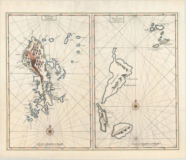
This sheet features two striking maps of smaller clusters of islands in northern Indonesia. The first shows the Sangihe Islands and is centered on the island of Sangir Besar. Within the island, numerous mountains are depicted, including the active volcano Mt. Awu, pictured here as massive and seeping flames. Forestation and several small buildings appear as well. In the water are myriad smaller islands and a couple anchorages. The Talaud Islands are the focus of the second map. Most of the islands in this group are dominated by large mountains. A scattering of soundings and an anchorage can be found in the waters surrounding the islands. Both maps are adorned with a distance scale and a compass rose capped with a fleur-de-lis and radiating rhumb lines.
Valentyn was a prominent historian of the Dutch East India Company who is best known for Oud en Nieuw Oost Indien, his vast illustrated account of the Dutch trading empire in Asia. He twice traveled to the East Indies and served as Calvinist minister to Ambon between 1686 and 1694. In preparing this monumental work, he was given privileged access to the previously secret archives of the VOC, containing transcripts and copies of important earlier Dutch voyages.
References: Shirley (BL Atlases) G.VALN-1a-7.1 & 7.2.
Condition: A
A crisp impression, issued folding with some faint offsetting.