Subject: Colonial Southeast
Period: 1781 (dated)
Publication: London Magazine
Color: Hand Color
Size:
13.6 x 10.9 inches
34.5 x 27.7 cm
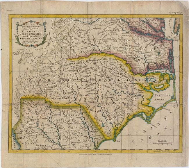
This map depicts the southern theater of war during the American Revolutionary War. The map shows the region from Richmond, Virginia to Orangeburg, South Carolina, and extends west to the Allegheny Mountains and the Savannah River. Numerous key locations are noted, including: the battle site at King's Mountain; the battle site at Guildford Court House; and Wilmington, North Carolina, where General Lord Cornwallis retreated for resupply before heading north into Virginia. Yorktown, Virginia is also shown, although this map was published several months before the Battle of Yorktown, the last major battle of the war. A dotted line near 36.5 degrees latitude depicts the northern boundary of the Granville District, an area previously under the control of the eight Lords Proprietor, and which was confiscated by the State of North Carolina in 1779. There is great detail of towns, forts, Indian tribes, rivers, and swamps. Counties are named but not delineated. Published by R. Baldwin. A rare and desirable map.
References: Jolly #LOND-342.
Condition: B+
Issued folding on watermarked paper, now pressed with minor soiling and professional repairs to a few tiny holes at fold intersections. There is a binding trim at right that has been replaced with old paper, and an associated binding tear that enters 2" into map that has also been professionally repaired.