Subject: Africa
Period: 1685 (dated)
Publication:
Color: Hand Color
Size:
34.9 x 21.8 inches
88.6 x 55.4 cm
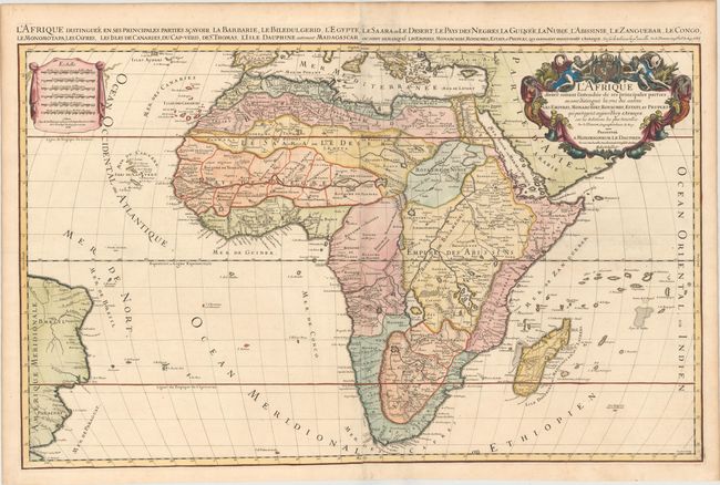
This striking map is Jaillot's map of the continent and is a larger version of Sanson's maps of 1650 and 1668. Engraved by Cordier, it is one of the early works in the collaboration between Sanson and Jaillot. The source of the Nile is shown emanating from two lakes below the equator. This map introduces a new depiction of the rivers south of these Ptolemaic lakes. The Zambeze River appears above the Zambere and Rio de Spiritu Santo, all of which flow into the Indian Ocean. A large section of South America is shown and two St. Helena islands appear - a common error in maps from this period. Six distance scales are presented on a drape-style cartouche. The very large and decorative title cartouche includes a tumult of figures, cornucopias, an elephant, a crocodile, a lion and an ostrich under the coat of arms of the Dauphin. Two sheets joined, as issued. This important map of the continent was copied by several other cartographers including Pieter Mortier and Marc Huguetan, who published their own edition of Jaillot's Atlas Nouveau in 1692, with Jaillot's imprint instead of their own. This is the second state, dated 1685. On two sheets, joined.
References: Betz #118.2; Norwich #46, Tooley (MCC-47) p. 46, plt. #16.
Condition: A
A fine impression on watermarked paper with a crease adjacent to joint and another crease in the Indian Ocean that has been professionally pressed and reinforced.