Subject: Holy Land, Eastern Mediterranean & Middle East
Period: 1612 (circa)
Publication:
Color: Hand Color
Size:
19.3 x 11.4 inches
49 x 29 cm
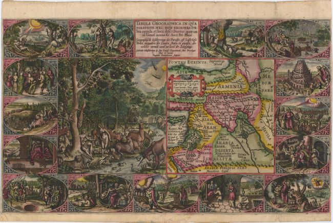
This is the second series of Dutch bible maps by Petrus Plancius, first published in 1604 by Johannes Cloppenburg. The first series consisted of a world map and 4 small maps of the Holy Land and Middle East, engraved by Johannes van Deutecum and his two sons, Johannes and Baptista. After Johannes van Deutecum (the younger) published a new set of maps in 1595, Plancius realized that his own maps required updating. He commissioned Baptista van Deutecum to engrave the second series, who also enlisted the assistance of engravers Daniel van Bremden and Pieter Bast. Plancius' second series retained the same world map (not included in this set) and 6 larger, re-engraved maps of the Holy Land and Middle East. The purpose of the maps was to help explain the biblical texts, but Plancius decided to take the maps one step further by adding 15 biblical vignettes surrounding each map, thereby transforming each map into a work of art. This matching set of maps are the first state of the second series, each with Dutch text on verso. Size varies slightly.
A. Tabula Geographica, in qua Paradisus, nec non Regiones, Urbes, Oppida, et Loca Describuntur; Quorum in Genesi Mentio Sit. This supremely graphic map features a large engraving of Adam and Eve in the Garden of Eden, surrounded by a variety of animals and birds. The scene is juxtaposed beside the map locating Paradisus just south of Babylon. The sheet is then further embellished with fifteen oval vignettes from Genesis. Engraved by Baptista van Doetichum, with the large Garden of Eden vignette engraved by Daniel van Bremden. References: Laor #565; Poortman & Augusteijn #73.
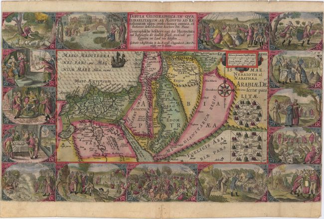
B. Tabula Geographica, in qua Iisraelitarum, ab Aegypto ad Kenahanaeam Usque Profectiones Omnes, et Stationes Describuntur. This extremely decorative Bible map illustrates the region surrounding the Dead Sea through the Nile Delta and depicts the wanderings of the Children of Israel. Beautifully engraved panels at the top and bottom include vignettes of important events of Exodus, Deuteronomy and Numbers. Inset within the map are two depictions of the Tribes surrounding the Tabernacle in the desert. The signature of the engraver P bast F (Peiter Base Fecit) appears in the vignette of Exodus 12 at left. References: Laor #566; Poortman & Augusteijn #75.
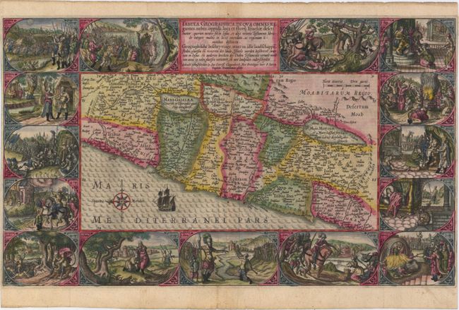
C. Tabula Geographica, in qua Omnes Regiones, Urbes, Oppida, Loca et Fluvii Israeliae Describuntur; Quorum Mentio Sit in Iosua, et Aliis Veteris Testamenti Libris de Integro Multis in Locis Emendata.... This map covers the region from Sidon to Rinocoruru and is oriented with north to the left. The Kishon River connects the Mediterranean with the Lake of Tiberia. The area is divided among the twelve tribes and is filled with place names and regions as mentioned in the Book of Joshua. Fifteen vignettes from the Book of Joshua surround the map including a scene of the battle between David and Goliath. Based on Jodocus Hondius' Terrae Promissionis quae Palestina Vocatur, Descriptio circa 1595, this is one of two maps added by Plancius for his second series of Bible maps. Engraved by Baptista van Deutecum. References: Laor #567; Poortman & Augusteijn #78.
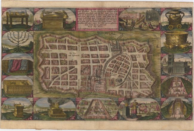
D. Waerachtige Beschryvinge Vande Wydvermaerde Conincklicke Hoost Stadt Ierusalem; Waerinne Oogenschynelick Verthoont Wordt de Eygenthicke Gelegenheydt Vande Oude Stadt.... This attractive plan of Jerusalem displays its well laid out streets and major religious sites within the outer walls, with west oriented to the top. Numerous market places are noted, including those for wood, cattle and fish. This is the second new map that was added to Plancius' second series of Biblical maps, and is based on Van Adrichem's plan. Fifteen Biblical vignettes surround the plan, including temple vessels and other religion icons. References: Laor #1101; Poortman & Augusteijn #79.
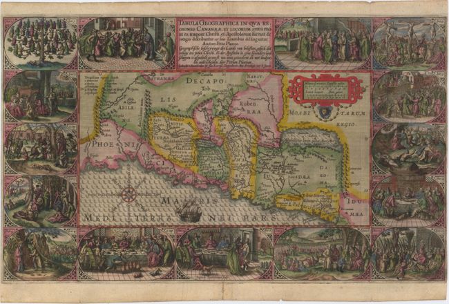
E. Tabula Geographica in qua Regiones Cananaeae, et Locorum Situs Prout ea Tempore Christi, et Apostolorum Suerunt de Integro Describuntur, ac Suis Limitibus Distinguntur. A superb and graphic map depicting the land of Canaan with political divisions during the time of Christ. Fifteen vignettes illustrating the life of Christ surround the map, beginning with the genealogy of Jesus and ending with his appearance to the disciples after the Resurrection. The map is nicely detailed and is decorated with a strapwork scale cartouche, sailing ship and a compass rose orienting north to the left. Engraved by Baptista van Deutecum. References: Laor #569; Poortman & Augusteijn #80.
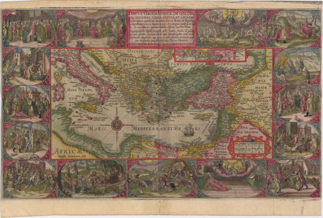
F. Tabula Geographica, in qua Omnes Regiones, Urbes, Oppida, et Loca Describuntur, Quorum Mentio Sit in Actis et Espistolis Apostolorum, et Apocalypsi; de Integro Multis in Locis Emendata, ac Regionum Suntibus Destincta. This superb map of the eastern Mediterranean, from Rome to Babylon, depicts the spread of Christianity as reported in the Acts of the Apostles. This is the final map of the standard set of Holy Land maps normally found in Dutch Bibles. The map is surrounded by fifteen Biblical vignettes including the apostles receiving heavenly inspiration, and the events of the Apocalypse as in the book of Revelations. The map includes a small inset of the whole Mediterranean region and is further decorated with a compass rose, sailing ship and strapwork distance scale. Engraved by Baptista van Deutecum. References: Laor #570; Poortman & Augusteijn #82.
References:
Condition: B
The maps are all early, dark impressions issued folding and now pressed with lovely, original color, with just a few minor touch-ups. The left and right side margins are very narrow, as issued. There are some short fold separations and cracks due to the oxidation of the green pigment that have all been professionally and archivally repaired. Map B has two small holes in the vignettes at bottom right and map D has a small hole in the center left vignette that have also been professionally repaired.