Subject: World
Period: 1745 (circa)
Publication:
Color: Hand Color
Size:
25.4 x 19.7 inches
64.5 x 50 cm
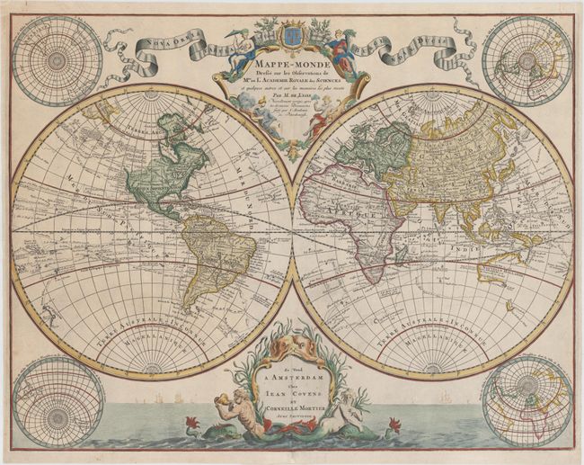
This handsome double hemisphere map is an updated version of Delisle’s first world map, issued in 1700. Delisle had used accounts from French explorers and colonizers of the Gulf of Mexico region, and also had access to accounts from survivors of La Salle’s expedition in the late 1680's. The tracks of major explorers and their discoveries are charted throughout the oceans. Although Covens & Mortier made numerous updates to Delisle's map, there are still several cartographic inaccuracies that remain. New Guinea is connected to Australia, however Nouv. Bretagne is now shown as a separate and very round island. In addition, Terre de la Compagnie still appears to the northeast of Japan. In this edition new information corrects the representation of the Great Lakes, South America, Japan as an island, and the Niger River in Africa. But the most interesting part of the map is the Pacific Northwest and the Bering Sea, where a conjectural coastline now appears with notations of the discoveries of Vitus Bering's first and second expeditions. A River of the West is also depicted almost connecting the Pacific to L. Winipigue.
The elegantly engraved title cartouche features female representations of the continents balanced by a ribbon-style banner. Covens & Mortier's imprint appears in a new and more decorative cartouche at bottom featuring sea monsters and mer-men, with a lovely seascape and sailing ships behind them. In addition, four polar projections have been added to the previously blank corners of the sheet, with partial outlines of Antarctica shown in the southern projections at left. A very lovely and rare map that features a wealth of cartographic information.
References: cf. Shirley #603.
Condition: B+
Attractive color on watermarked paper with a few small spots of foxing and professional repairs along centerfold at top and bottom. There is a 1.3" tear adjacent to centerfold at bottom of image that has also been professionally repaired.