Subject: Gulf of Mexico, Texas
Period: 1803 (dated)
Publication:
Color: Hand Color
Size:
36.6 x 24 inches
93 x 61 cm
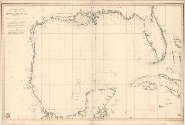
First published in 1799, this was the earliest chart to name the bays of Galveston and Bernardo (now Matagorda) in Texas. Streeter writes that this map is one of six maps "especially desirable for a Texas collection" as this map "represents a real advance" in the charting of "the Texas coast line and the lower courses of its rivers." As such, it became the prototype for maps of the Gulf for many years and was even used by Humboldt in creating his Carte Generale du Royaume de la Nouvelle Espagne, another highly regarded map.
This map was the first chart of the Texas coast based on actual soundings and exploration. The exploration was conducted by Jose Antonio de Evia in 1785-86, who named Galveston Bay after his patron, Bernardo de Galvez, the interim governor of Spanish Louisiana. Evia explored the coasts of Florida, Alabama, Mississippi, Louisiana, Texas and Mexico, ending in Tampico. The chart extends from Florida to the Yucatan peninsula, and includes parts of Cuba and the Bahamas. One of the key features is the depiction of six of the seven important rivers in Texas, with the Brazos River oddly missing. The map depicts the lower courses of the Sabine, Trinity (Archisas), Colorado, Guadalupe (San Marcos), Nueces, and Rio Grande.
A key below the title includes a lettered guide to the composition of the Gulf floor as indicated on the map, and lists the symbols that correspond to the astronomical observations of longitude and latitude. The seal of the Deposito Hidrografico is at bottom left with the price Precio 18 rs vn just below. The map was engraved by Felipe Bauza and Fernando Selma, whose imprints appear below the neatline at bottom right and left. This is the second state with additional astronomical observations updated through 1803. This map is extremely rare - we only know of one other example (1799 edition) that has gone up for sale in the last 30 years.
References: Streeter (Part III) p. xv and #1029A; Martin & Martin, p. 105.
Condition: B+
Old color with minor soiling and a few faint stains. There is an extraneous crease adjacent to the centerfold and a printer's crease at top (to the right of the title) that has been archivally reinforced on verso. There are a few spots of foxing and light toning along the centerfold, which has also been archivally reinforced on verso. The right margin is very narrow at bottom.