Subject: Southwestern United States & Mexico, Texas
Period: 1841 (dated)
Publication: Atlas Universel
Color: Hand Color
Size:
15.8 x 21.5 inches
40.1 x 54.6 cm
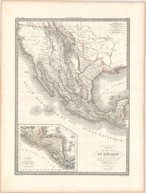
An attractive map that shows the Southwestern United States through Mexico to the Yucatan with an inset of Central America. This map shows the Republic of Texas with Mexico encompassing the southwest. This map went through some fascinating changes during its lifetime. First published in 1829, the map showed Mexico extending to include Texas and the entire Southwest. The Rocky Mountains were well delineated by hachure and incorporated information from Humboldt, Pike, and Long. The American Southwest reflected cartography that predated Fremont and Smith’s explorations, including two Salt Lakes and the mythical rivers that connect them to the Pacific. The large blank area to the far west was labeled Partie Inconnue (part unknown). For the 1838 edition, the area within Texas was completely re-engraved to show Texas as a Republic, with the addition of a dashed western boundary. Numerous additional changes were made within Texas, including updating the location and names of various rivers, updating and adding new towns, revising the road that extended through Texas, and marking San Felipe de Austin as the capital. Although San Felipe de Austin had been the first capital designated in the Republic of Texas, it had moved several times and was actually in Houston by 1836. However, no changes were made to Arkansas, which had become a state in 1836. This edition, dated 1841, appears identical to the 1838 edition except for the date change in the title cartouche. Engraved by Tardieu.
References:
Condition: A
Original outline color on a bright sheet with wide margins and light toning along sheet edges.