Subject: Boston, Massachusetts
Period: 1775 (dated)
Publication:
Color: Hand Color
Size:
13.7 x 13.6 inches
34.8 x 34.5 cm
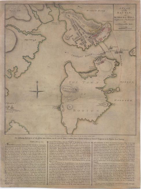
This very rare broadside gives a fascinating British perspective on the Battle of Bunkers Hill. The map gives a panoramic scene of the warfare from the Charlestown Neck north of the Charlestown Peninsula to the Roxbury Neck just south of Boston. The plan depicts the locations and movements of the major players during the battle. Warren's redoubt and several lines of American forces are shown in yellow along Breed's Hill (which is not named), adjacent to the city of Charlestown. The advancements of General Howe and Brigadier General Pigot are depicted in red moving from the beach north towards Breed's Hill. British warships are shown at the mouth of the Charles River. There is scarce detail within the town of Boston with the exception of several British fortifications, including a fort, two redoubts, batteries, and the location of Generals Burgoyne and Clinton's troops during the battle at the Cobbs Hill battery.
One of the most interesting aspects of the plan is a note near the Charlestown Neck, "Hither the ships ought to have come," referring to General Clinton's recommendation that the British attack the rebels from the north, thereby preventing their retreat. Clinton was outvoted by his fellow generals, and the Battle of Bunkers Hill resulted in a costly victory for the British army due to the number of casualties. In addition, the conflict served as one of the first steps towards American Independence by giving the rebels a moral victory and the determination to carry on with the war.
One week after the battle, General Burgoyne wrote a letter to his nephew Lord Stanley, describing the battle in colorful detail. The letter is reproduced below the map, and explains how the British realized that control over Boston was dependent on the British also securing both the Charlestown and Dorchester peninsulas. Burgoyne explains that although he and his fellow commanding officers had determined to attack Dorchester first (scheduled for June 18th), after hearing of the movements of the colonials in the north, they shifted their focus to Charlestown and Bunkers Hill. After describing the operations of the British troops, the ensuing battle, and the heroism of the British army, Burgoyne lists the key casualties of the confrontation.
This broadside was separately issued by Sayer & Bennett on November 27, 1775 and is historically significant both for its broad view of the full battlefield and for Burgoyne's important account of the battle. Full sheet with text measures 19.6 x 14.6". This is a unique opportunity to own an example of this rare map that has been expertly repaired and conserved for a fraction of the cost of its typical retail value of $30,000-50,000.
References: Nebenzahl & Higginbotham (Amer. Rev.) #3; Nebenzahl (Bibliography) #28.
Condition: C
This map has been expertly conserved, with numerous small chips into image at top, left and bottom, as well as a 1 x 10" strip along the right-hand edge at bottom all repaired with image skillfully and seamlessly replaced in facsimile. Remargined on all sides and backed in Japanese tissue to repair a few short tears in the image. On watermarked paper with a few small abrasions, toning, and moderate soiling. There are also minute pinholes along the engraved lines of the map (now reinforced with the Japanese tissue on verso), indicating that a previous owner made a manuscript copy of the map.