Subject: Eastern Australia
Period: 1774 (published)
Publication: Relation des Voyages
Color: Black & White
Size:
13.2 x 5.3 inches
33.5 x 13.5 cm
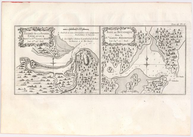
This rare plate contains two charts on one sheet. On the right is the depiction of Botany Bay when Cook first landed in Australia on April 29, 1770. Six locations for fresh water are noted as are several soundings in the harbor with shoals delineated. Locates C. Banks and Pt. Solander which were named by Cook for his botanists Joseph Banks and Daniel Solander.
The chart on the left shows the entrance of the Endeavour River in northern Queensland. It locates the "place where we landed our equipment" and the "place where we repaired the ship." Cook departed Botany Bay continuing northwards where, on June 11, the Endeavour ran aground on a shoal of the Great Barrier Reef. The ship was badly damaged and his voyage was delayed for seven weeks while repairs were accomplished on the site marked on this map. This is near the town of Cooktown. After the repairs were completed the voyage continued and resulted in Cook claiming the entire eastern coastline of Australia on August 22 for England. The return trip to England was via Batavia, the Cape of Good Hope and the island of Saint Helena, finally arriving July 12, 1771. The two charts are within their own border (neatline) and are on a full sheet measuring 17" x 11.2". The maps were published in the French edition of Hawkesworth's account of Cook's voyage to Australia.
References: Tooley (Australia), p. 235 #4.
Condition: A
Faint offsetting and minor soiling in the wide blank margins.