Subject: World
Period: 1708 (dated)
Publication:
Color: Hand Color
Size:
23.3 x 17.7 inches
59.2 x 45 cm
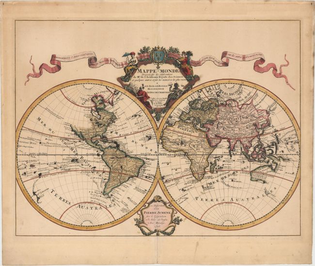
This handsome double hemisphere map is a corrected version of Delisle’s first world map, issued in 1700. The address notation in the lower cartouche removes Delisle's address in favor of Schenk's imprint. In this edition new information corrects the representation of the Great Lakes, South America, and the Niger River in Africa. In keeping with Delisle's desire for accuracy, the northwestern portion of North America is not illustrated here and there is no evidence of Antarctica. Delisle used accounts from French explorers and colonizers of the Gulf of Mexico region. He also had access to accounts from survivors of La Salle’s expedition in the late 1680's. Despite his efforts to produce highly accurate maps, this map shows New Guinea connected to Australia, and it appears that Japan is connected to the mainland (Terre de Yeco) to the north. In addition, Terre de la Compagnie appears to the northeast of Japan with a partial outline continuing in the western hemisphere accompanied by a note regarding its discovery by Dom Jean de Gama. The tracks of major explorers and their discoveries are charted in the oceans. The elegantly engraved title cartouche features female representations of the continents balanced by a ribbon-style banner advertising Delisle’s upcoming book, Nouvelle Introduction a la Geographie.
References: Shirley #603.
Condition: B+
A nice impression with full original color, a few errant spots of color, minor soiling, and a professionally repaired centerfold separation that enters 1.5" into image at bottom.