Subject: Gulf of Mexico & Caribbean
Period: 1775 (dated)
Publication: The West Indian Atlas
Color: Hand Color
Size:
48.4 x 18.8 inches
122.9 x 47.8 cm
Thomas Jefferys was one of the most important English map publishers of the 18th century. His work included prints and maps of locations around the world, but his most notable maps are of North America and the West Indies. He began his career in the map trade in the early 1730s, working as an engraver for a variety of London publishers, and eventually setting up his own shop. In 1746, he was appointed Geographer to the Prince of Wales, and in 1760 he became Geographer to the King. These titles granted access to manuscripts and cartographic information held by the government. In the early 1760s he embarked on an ambitious project to produce a series of English county maps based on new surveys, but ran out of money and filed for bankruptcy in 1766. He then partnered with London publisher Robert Sayer, who reissued many of Jefferys plates and continued to issue new editions after Jefferys' death in 1771. Jefferys' American Atlas and the accompanying West-India Atlas, published post posthumously, are considered his most important cartographic works.
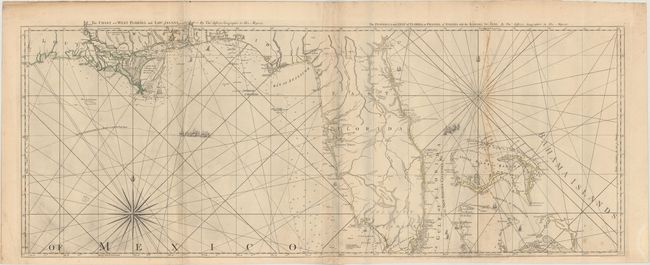
This is the first state of this fine, large sea chart covering the Gulf Coast from Cabo del Norte, Louisiana, through Florida to the Bahamas. This naval chart is one of the most important maps of Florida, being the earliest relatively accurate map of the region. The hydrographic detail of the coastline and the channels in the Bahamas is excellent and it remained the standard sailing chart for the Florida seas during the last part of the 18th century. Detail is primarily confined to the coastline with harbors, inlets, bays, river entrances, soundings, rocks, shoals, and currents carefully noted. Several forts, settlements, and villages are located and the start of the road from Fort St. Marks to St. Augustine is shown. The map is ornamented with a dramatic compass rose, rhumb lines, and a fleet of sailing ships marking "The Flota's Track from la Vera Cruz to Havanna to avoid the Trade Winds." In this first state, the bay at the mouth of the Mississippi River is unnamed but bears a note "Shallow Water with many small Islands but very little known." This two-sheet map is part of the sixteen-sheet map of the West Indies that formed the heart of this important Revolutionary-period atlas. Sheet number DG.4 printed at upper right, and the imprint of Robert Sayer at bottom.
References: Sellers & Van Ee #1608; Shirley (BL Atlases) M.JEF-4a #9.
Condition: B+
A crisp impression with original outline color on thick watermarked paper. There is light soiling, minor printer's ink residue at bottom left, some foxing on the right, and a few extraneous creases. There is a damp stain in the bottom right margin, well away from map image.