Subject: Charleston, South Carolina
Period: 1858-65 (dated)
Publication:
Color:
The Office of Coast Survey is the oldest U.S. scientific organization, dating from 1807 when Congress directed that a "survey of the coast" be carried out. By 1836, it was called the U.S. Coast Survey and in 1878, the name was changed to the U.S. Coast and Geodetic Survey. Today the Office of Coast Survey is a division of the National Oceanic and Atmospheric Administration NOAA.
The survey teams, composed of civilians as well as Army and Naval officers, charted the nation's waterways and produced a wide array of reports, survey charts, hydrographic studies of tides and currents, astronomical studies and observations, and coastal pilots. These charts are an important record of the changing nature of the nation's coastlines. In additional to coastal charts, the U.S. Coast and Geodetic Survey produced land sketches, Civil War battle maps, and the early aeronautical charts.
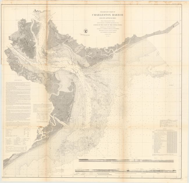
A. Preliminary Chart of Charleston and Its Approaches, dated 1858, black & white (31.8 x 30.8"). This fine chart of Charleston Harbor extends to show Charlestown and further inland to the confluence of the Cooper and Wando Rivers and part of the Ashley River. It locates the forts of Sumter and Moultrie. It includes soundings, navigational channels, hazards, beacons and lighthouses. For a coastal chart, the inland detail is remarkable with plans of Charleston, Mount Pleasant and Moultrieville, plus land and rivers delineated. St. Michaels and St. Phillips are named in Charleston and the light ship at Rattlesnake Shoals is noted. Two sea views at bottom show the coastline as seen from onboard an approaching vessel. Condition: Issued folding with several tiny splits along the folds partially closed on verso with archival tape. Trimmed to inside the neatline at left with some minor toning along the folds.
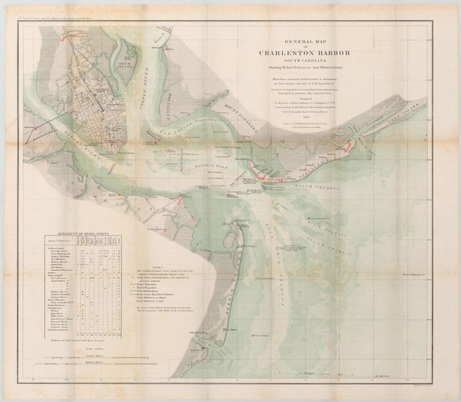
B. General Map of Charleston Harbor South Carolina Showing Rebel Defenses and Obstructions, dated 1865, hand color (24.8 x 21.9"). This fascinating map was produced under the direction of Rear Admiral J.A. Dahlgren U.S.N. commanding South Atlantic Blockading Squadron, by C.O. Boutelle Asst. U.S. Coast Survey. It shows the surveys of the shore line, channels, and fortifications with the location of Union and Rebel Batteries shown in color. It details positions of shipwrecks, obstructions, and torpedoes including the Housatonic, Keokuk and Flamingo. Tracks of numerous torpedoes are detailed. Many interesting notes include one giving the position of Ironsides as it lay over a 2,000 pound torpedo for "one hour" on April 7th, 1863. Table at lower left, Armament of Rebel Forts and notes explain the various symbols on the map. Charleston is shown as a detailed street grid. Possibly the best chart of Charleston Harbor produced during the Civil War. Extends to include Forts Shaw, Marshall, Sumter, Wagner and Johnson, plus many batteries. Condition: Light, scattered foxing and some toning mainly along the folds.
References:
Condition: B
See descriptions above.