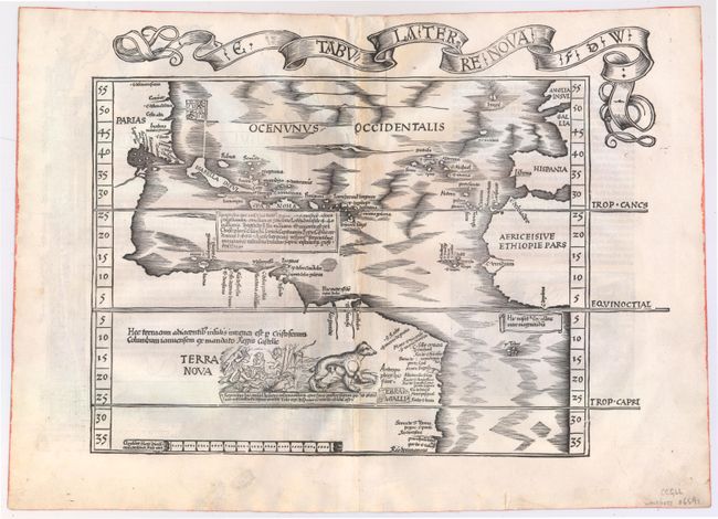
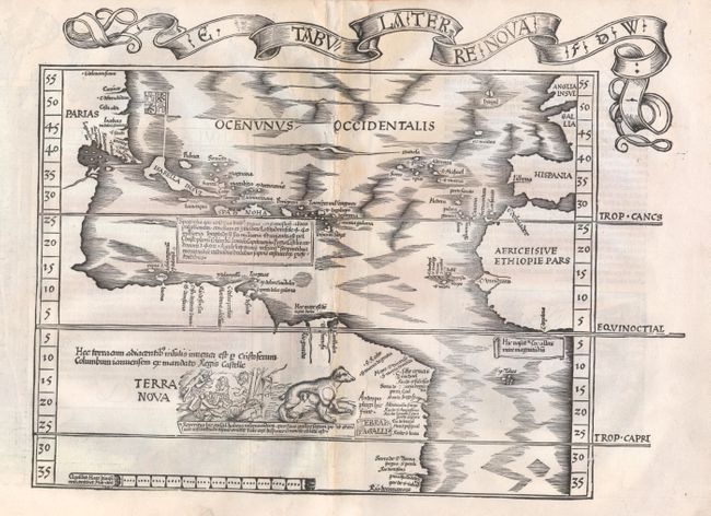
Subject: Western Hemisphere - America, Atlantic Ocean
Period: 1522 (published)
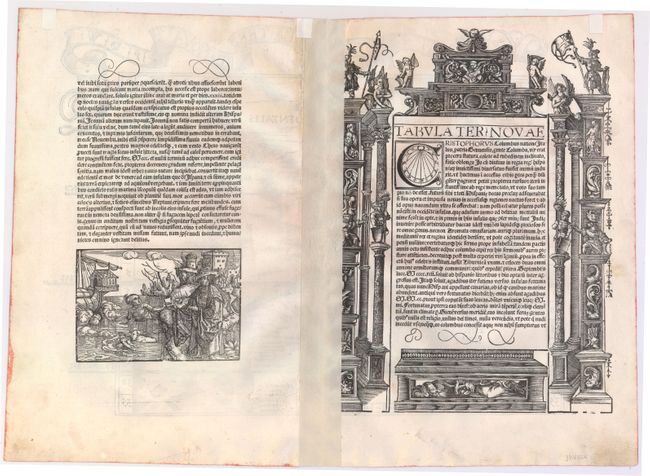
Publication: Opus Geographiae
Color: Black & White
Size:
17.1 x 12.8 inches
43.4 x 32.5 cm
This is Laurent Fries' slightly reduced, and more decorative, version of Waldseemuller's landmark map covering the Atlantic coastline of the Americas. It is one of the earliest maps available to collectors of American maps. Waldseemuller's map was the first map devoted to the Americas to appear in an atlas. His map is often referred to as the Admiral Map because Waldseemuller attributed his source of information on the New World to 'the Admiral' - referring to Columbus. This was a change, however from his 12-sheet world map of 1507, on which Waldseemuller named the new continent America after Amerigo Vespucci. He soon realized his error and corrected it on his map of the Americas, first published in 1513, in which the new world was named simply Terra Incognita. Waldseemuller attempted further to distance himself from the false credit he had given to Vespucci by specifically crediting Columbus with two lines of Latin text, which read, "Hec terra cum adiacentib insulis inuenta est per Columbu ianuensem ex mandato Regis Castelle" (this land with its adjacent islands was discovered by Columbus, sent by authority of the King of Castile). Waldseemuller also used Portuguese manuscript maps as sources, including the portolan charts by Cantino (1502) and Caveri (circa 1505), particularly for the coastal place names shown in North America.
The geography of Fries' map follows that of the 1513 Waldseemuller and delineates the Atlantic from latitudes 35° south to 55° north, with a surprisingly accurate depiction of the American coastline. Fries added the Spanish flag flying over Cuba (named Isabella after the Queen of Spain) and a text block beneath Hispaniola describes the island and Christopher Columbus' discoveries in 1492. He also added graphic depictions of cannibals and a fierce-looking opossum, both of which had been reported by Amerigo Vespucci. He renamed the new world Terra Nova and retained the two famous lines of Latin text from the 1513 edition. This is the very rare first edition, which was published in 1522 and is the only edition with a decorative ribbon banner title cartouche above the map.
References: Burden #4; Goss (NA) #3; Portinaro & Knirsch, pp. 64-65.
Condition: B+
A nice impression on watermarked paper with full, original margins. There is light toning along centerfold, a hint of offsetting, and minor soiling in blank margins. There are a few minor professional repairs along centerfold and to a small hole in bottom blank margin, far from image. Remnants of hinge tape on verso.