Subject: World
Period: 1749 (circa)
Publication: Geographie Universelle
Color: Hand Color
Size:
7 x 5.5 inches
17.8 x 14 cm
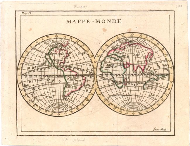
Attractive small double hemisphere map shows the Western Hemisphere with California as an island off the western coast of North America. The depiction of California as an island appeared on maps for over 100 years from approximately 1624 to the early 18th century, after Father Kino, a Jesuit missionary, walked across the top of the Baja Peninsula from the mainland to the coast in 1698, thereby disproving the theory. In 1705 his map was published in Europe, but it was not accepted until another Jesuit, Father Consag sailed completely around the Gulf in 1746, and King Ferdinand of Spain issued a decree a year later in 1747 announcing finally that “California is not an Island.” Claude Buffier, a theologian and geographer from Warsaw working in Paris, first published this map in 1715, and published a further 17 French editions up to 1785 without updating the geography on this map. In the eastern hemisphere, only the western coast of Australia is drawn, as the eastern coast had not yet been charted by Capt. Cook, who surveyed it years later in 1769. Although land contours on this small map are drawn in a speculative fashion, the charm of the map lies in its inaccuracies and the lack of universal knowledge still apparent in mapmaking in some European centers in the early 18th century. Engraved by Faure.
References: Shirley (BL Atlases) T.BUFF-2a #1.
Condition: B+
Issued folding, now pressed, with light offsetting, a hint of toning, and a few small spots.