Subject: Western Hemisphere - America
Period: 1633 (circa)
Publication: Atlantis Pars Altera
Color: Hand Color
Size:
18 x 14.5 inches
45.7 x 36.8 cm
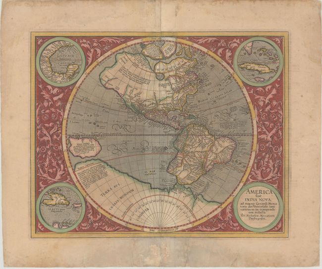
This is one of the most famous maps of the Americas and an important foundation map for an American map collection. After the death of his grandfather, Michael Mercator produced this stunning hemispherical map, the only known printed map attributed to him. The map is surrounded by a beautifully engraved floral design and four roundels, one of which contains the title. The other insets include the Gulf of Mexico, Cuba, and Haiti. The geography was patterned after Rumold Mercator's world map of 1587, with a little added detail. There is a large inland lake in Canada, and the St Lawrence River extends nearly halfway across the continent with no Great Lakes. There is a still a bulge in the west coast of South America. The large southern continent extends above the Tropic of Capricorn in the Pacific where there is a very large island of New Guinea. Above North America are two of the four islands of the North Pole, with the great mythical rivers flowing from the pole. The seas are full of mythical islands, including St. Brendain, Frislant and Sept citez. French text on verso with page number 69 and signature S, indicating it was published between 1633-39.
References: Burden #87.
Condition: B
Attractive color with wide margins. The centerfold has been backed with old paper to reinforce and repair numerous separations and several small abrasions with minor loss of image. There are several minor extraneous creases going through South America and the Pacific Ocean and some damp stains primarily confined to the top and bottom blank margins.