Catalog Archive
Auction 143, Lot 735

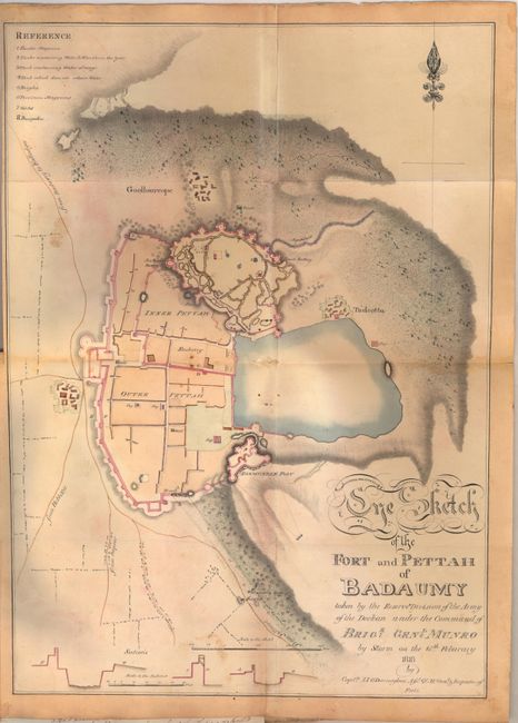
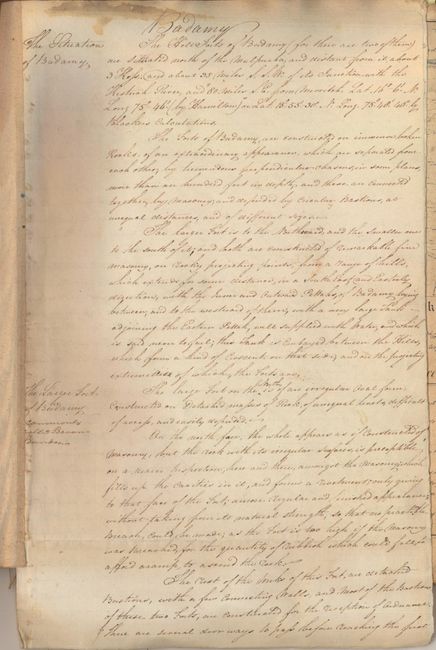
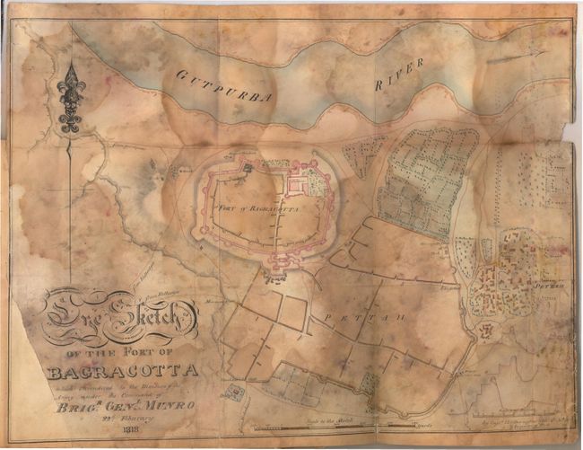
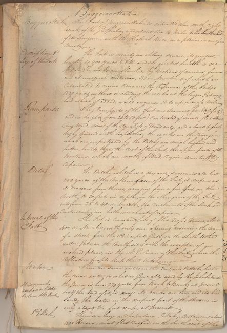
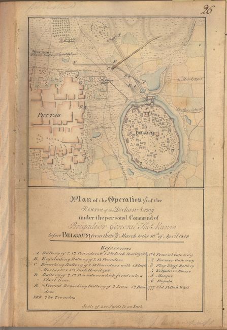
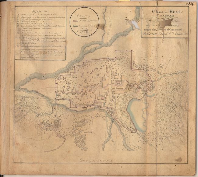
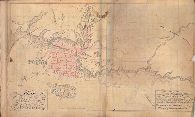
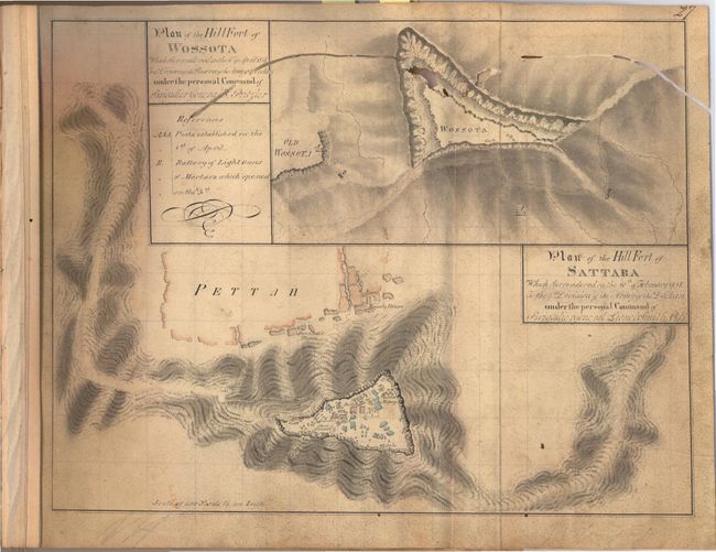
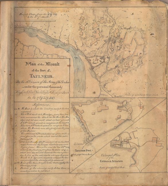
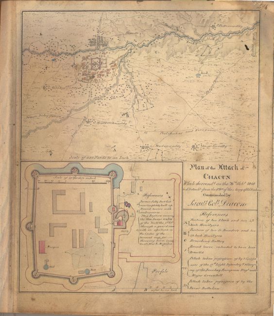
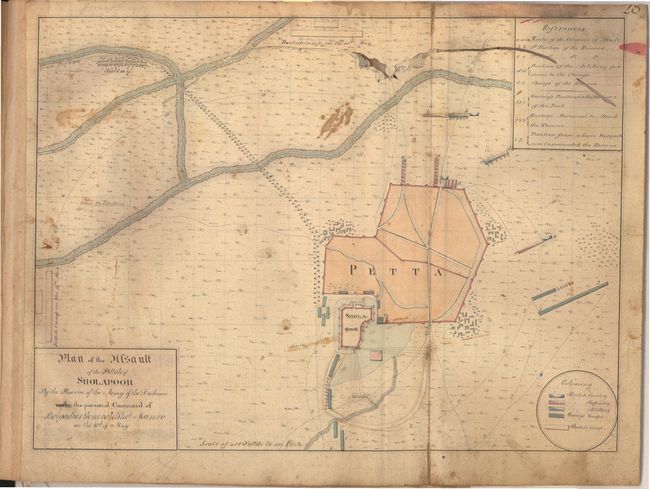
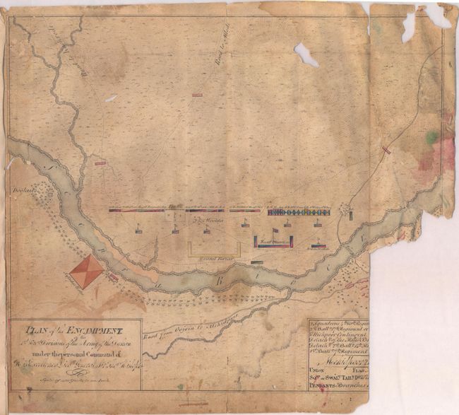
British Manuscript Battle Plans and Notes from the Third Maratha War

"[Set of 25 Manuscript Maps and Notes from the Third Maratha War]",

Subject: India

Period: 1819-21 (circa)

Publication:

Color: Hand Color

Size:
11 x 11.5 inches
27.9 x 29.2 cm
Download High Resolution Image
(or just click on image to launch the Zoom viewer)

This is a fascinating set of 25 manuscript maps from the Third Anglo-Maratha War (1817-1819). This war was the final conflict between the British East India Company and the Maratha Empire in India, and resulted in the end of the Maratha Empire and the firm establishment of the British East India Company in India. The Maratha Empire (also known as Mahratta) was founded in 1674 by Shivaji Bhosle with Raigad, just south of Bombay, as the capital. During its height, the Empire controlled most of India, but found itself in frequent conflicts with rival tribes over land and power. Starting in 1775, the British East India Company began intervening in a succession of disputes between the Maratha and its rivals, offering aid and protection to the rivals in exchange for British paramountcy, which led to the First Anglo-Maratha War. The Third Anglo-Maratha War began with an invasion of over 100,000 British troops in Maratha territory, and ended with the British gaining control of almost all of present-day India, south of the Sutlej River.

The maps in this lot depict encampments and battle plans during the war. Two of the maps are by Captain I.I. O'Donnoghue, who credits himself as "Afst. Qr. Mr. Gent. & Inspector of Forts." Each of his maps are accompanied by several pages of manuscript notes describing the areas depicted on the maps. Sketch of the Fort and Pettah of Badaumy Taken by the Reserve Division of the Army of the Deckan under the Command of Brigr. Genl. Munro by Storm on the 18th February 1818 depicts a small fortified hilltop village located near Dharwad in southern India. The notes that accompany this plan describe the forts in detail, including information on the construction, location, availability of water, inner and outer Pettahs, weaknesses, and ways in which the forts could be attacked. O'Donnoghue concludes his report with a recommendation that "it would be desirable, that these forts should be armed, as from the peculiar nature of the access to them, it will be a most laborious, and difficult undertaking; and which will be utterly impossible to accomplish, on an emergency." Sketch of the Fort of Bagracotta which Surrendered to the Division of the Army under the Command of Brigr. Genl. Munro 22nd February 1818 depicts a fort and the surrounding plain along the Gutpurba River (most likely the Ghatprabha River), also near Dharwad. The accompanying notes are dated February 1821, and again give extensive details of the fort and its potential weaknesses if under attack.

The remaining twenty-three plans are nearly identical to those published in 1821 by Lieut. Colonel Valentine Blacker in "Maps and Plans Illustrating the Memoir of the Operations of the British Army in India, during the Mahratta War of 1817, 1818, & 1819," with maps engraved by Sidney Hall. Blacker's book contains a total of 38 plans, and the plans numbered 13-37 (with the exception of plan 22) are included in this set of manuscript maps. These manuscript plans include the attacks on Belgaum and Chandrapur (Chandah), the environs of Indore (Indoor), and the hill fort at Sattara. The 23 manuscript plans are not signed, and several differ slightly from the engraved versions. It is certainly possible that these manuscript plans served as the basis for the engraved examples in Blacker's book. For a comparison of the engraved versions of the map, there is a scanned example of Blacker's book available online through the Harvard University Library: click here.

All 25 maps are hand-drawn in black ink with original hand coloring on heavy wove paper, some with watermarks. The manuscript notes are written in brown ink on hand-laid watermarked paper (some with a "J. Whatman 1819" watermark). The maps and notes are mounted on backstraps and bound together with string. It appears that the set was originally encased in blue paper covers, but all that remains is blue paper along the spine.

References:

Condition: C

The maps range in condition from good to poor, with soiling, damp stains, and numerous large worm tracks. There are many tears and fold separations, all of which have been closed on verso with archival tape. Eight of the maps are missing a portion of the map or legend at right. The manuscript notes are in very good condition with light soiling and a few small worm tracks. It appears that this set of maps was heavily used.

Estimate: $1,000 - $2,000

Sold for: $8,000

Closed on 2/13/2013

Archived