Subject: Quebec, Canada
Period: 1759-60 (circa)
Publication:
Color: Black & White
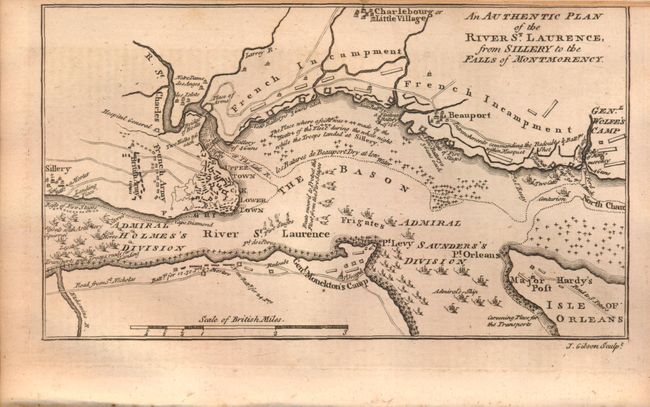
A. An Authentic Plan of the River St. Laurence, from Sillery to the Falls of Montmorency, from The Gentleman's Magazine, published 1759 (7.4 x 4.2"). This map details the 1759 "Battle of Quebec" during the French and Indian War. It was issued shortly after the capture of Quebec and shows the positions of all the British and French troops and their lines, defensive works, encampments, and numerous warships in the river, some named. This small map delineates rivers, roads, and towns in the vicinity around Quebec. Very detailed on a scale of about one inch per mile. An important French and Indian war map that was published half-way through the conflict. Engraved by John Gibson, and still bound into the November 1759 issue of the Gentleman's Magazine. Condition: Light toning with the top margin trimmed to the neatline as issued. (B+)
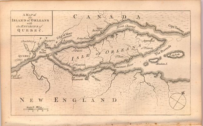
B. A Map of the Island of Orleans with the Environs of Quebec, from The Gentleman's Magazine, published 1759 (7.4 x 4.3"). This uncommon French and Indian War map was published in the October 1759 edition of Gentleman's Magazine. At the time Quebec was France's strongest fortress in Canada. The nearly three month long siege ended on September 18th, 1759, when the French surrendered to the British General Wolfe. This victory was the turning point of the war. Centered on the Isle of Orleans the map locates Quebec, The Bason, Cape Torment, The Traverse, Beaumont, and the falls of Chaudiere and Montmorenci. British scale of miles and simple compass rose. Still bound into the October 1759 issue, which also includes a map showing the European theater of war in Minden, Germany entitled Plan of the Battle of Thornhausen. Condition: Light toning (B+)
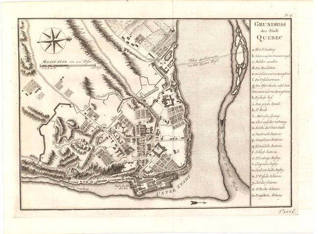
C. Grundriss der Stadt Quebec, by Bellin, circa 1760 (11.0 x 7.6"). German edition. This attractive and historical map of Quebec presents the city as it would have appeared when the French surrendered at the end of the French and Indian War. It is based on earlier plans by Bellin, first published in 1744, that continued to be the definitive view for many years. The list at right names and keys 24 buildings, batteries and forts; it locates Fort S. Louis, the Hotel Dieu and St. Roch. The map locates Ancient retrenchment, the high village, and more. This terrific plan is oriented with north to the right as indicated by a decorative compass rose with fleur-de-lys. Condition: (A+)
References: Jolly (Maps of America) #122; Jolly #GENT-136 & 137.
Condition:
See descriptions above.