Catalog Archive
Auction 142, Lot 264

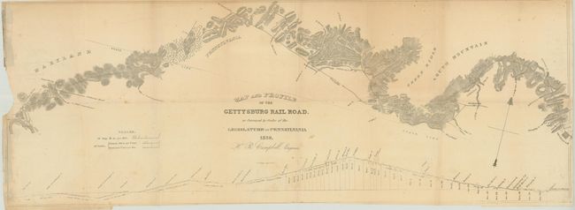
"Map and Profile of the Gettysburg Rail Road. as Surveyed by Order of the Legislature of Pennsylvania",

Subject: Pennsylvania

Period: 1839 (dated)

Publication:

Color: Black & White

Size:
33 x 12 inches
83.8 x 30.5 cm
Download High Resolution Image
(or just click on image to launch the Zoom viewer)

This early railroad map shows the Gettysburg Rail Road as surveyed by order of the legislature of Pennsylvania, 1839. The proposed tracks run from Gettysburg, Pennsylvania to Big Spring, Maryland, and shows good topographical detail in the immediate vicinity of the tracks. At bottom is a profile view demonstrating the elevation change. Drawn by H.R. Campbell.

References:

Condition: B

Issued folding with some minor loss at left in an unengraved area, a few minor spots of foxing, and some light toning.

Estimate: $200 - $250

Sold for: $120

Closed on 11/28/2012

Archived