Subject: Asia
Period: 1550 (circa)
Publication: Cosmographia
Color: Hand Color
Size:
13.7 x 10.8 inches
34.8 x 27.4 cm
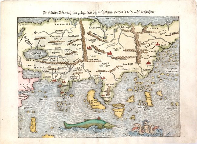
This map is based on the recent geographical discoveries by Portuguese navigators. The outline of the Asian mainland is relatively well-established, but Munster omits the extreme northeast of Asia, still believed to be joined to the New World. Japan is also lacking, as it appeared on Munster's New World map instead. India appears as a peninsula and Sri Lanka, called Zaylon, is correctly located. Cambay, Goa and Cannonore are all shown, reflecting the Portuguese presence on India's west coast, and this edition names Calicut, unlike the earlier examples of the map. Malacca is correctly located on the Malay Peninsula and the Indonesian island of Sumatra has inherited the name Taprobana from Sri Lanka, but also bears the name Sumatra. Java appears as two islands, Java Maior and Java Minor, shown north of the other. The famed Spice Islands of the Moluccas are located, but oddly shaped. An archipelago of 7448 islands lies off the eastern coastline of China, from the reports of Marco Polo. A huge sea monster and a fantastic two-tailed mermaid preside over the Indian Ocean. German text on verso.
References: Yeo #2; Walter #8A.
Condition: B+
A nice impression with attractive color, light show-through of text on verso, and minor soiling primarily in the blank margins. There are a few worm holes in top and bottom blank margins that just enter 1/4" into image, and a hole along centerfold at center of map that have all been expertly repaired with a small amount of image in facsimile.