Subject: Texas
Period: 1861-76 (circa)
Publication:
Color: Hand Color
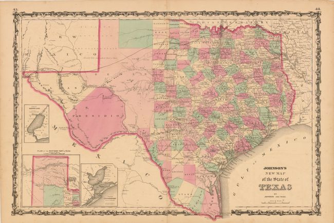
A. Johnson's New Map of the State of Texas, by Johnson and Ward, from Illustrated Family Atlas of the World , circa 1861, hand colored (24" x 16"). The first edition of this handsome map, with county development mostly in eastern Texas and only the three large counties of El Paso, Presidio, and Bexar in the west. The panhandle, noted as the Staked Plain (Elevated Table Land, without Wood or Water), includes a large section that is unorganized. There are numerous wagon roads, a few completed railroads, and the US Mail Route traced on the chart. Insets include a Plan of Sabine Lake, Plan of the Northern part of Texas, and Plan of Galveston Bay. Surrounded by Johnson's early strapwork border. Condition: There is a bottom centerfold separation closed on verso with archival tape that just passes the neatline, some minor foxing and offsetting, and one tiny wormhole only visible when held to light. (B+)
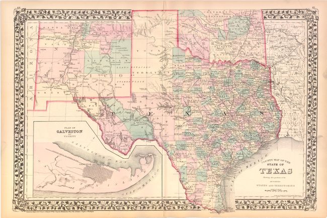
B. County Map of the State of Texas Showing also Portions of the Adjoining States and Territories, by Samuel Augustus Mitchell, from General Atlas, dated 1876, hand colored (14" x 21"). This fine double-page map of Texas extends to include most of New Mexico to above Santa Fe and the adjoining parts of Oklahoma, Arkansas and Louisiana. The map presents an excellent view of the county development with only the large regions of West Texas yet to be organized. Galveston’s role as a main port of entry is obvious as it is depicted in a large inset. The Llano Estacado, or Staked Plain, is shown extending from the New Mexico Territory through the Texas panhandle. Indian Territory is divided into several large Indian nations and reservations. The map is surrounded by Mitchell's distinctive grapevine border. Drawn and engraved in Philadelphia by W. H. Gamble. Condition: There are two small centerfold separations at top and bottom that enter 1/2" into map, all of which have been closed on verso with archival tape. There is a 1/2" tear adjacent to the centerfold in the panhandle, as well as some minor edge tears (only one of which just passes the neatline), that have all been closed on verso with archival tape. (B)
References:
Condition:
See descriptions above.