Subject: Erie Canal, New York
Period: 1835 (dated)
Publication:
Color: Black & White
Size:
48.5 x 28 inches
123.2 x 71.1 cm
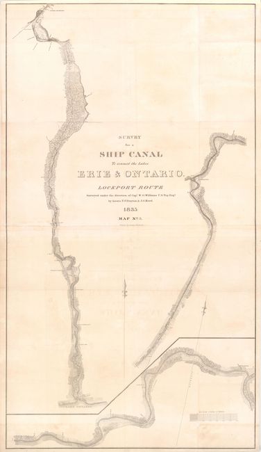
This detailed strip map shows a proposed water route between Lake Ontario and Lake Erie in upstate New York, designed to avoid Niagara Falls. The route begins at Lake Ontario, just north of Lockport, with the Eighteen Mile Creek, so named because of its distance from Niagara River, not its length. After passing through Lockport, the waterway connects with the Erie Canal, Tonawanda (Tonnawanta) Creek, and the Niagara River before flowing into Lake Erie. The Erie Canal, which was completed in 1825, stretches from Albany, NY on the Hudson River to Buffalo, NY on Lake Erie. This route was surveyed by Lieutenants T. F. Drayton and J. G. Reed under the direction of Capt. W. G. Williams, U.S. Topographical Engineers. Printed on two sheets, joined.
References:
Condition: B
Folding with minor offsetting, light soiling and a few creases. There are fold separations and tiny holes along folds that have been archivally repaired. There are 3" chips at left near the center and in bottom left corner that have been reattached with archival materials.