Subject: World
Period: 1700 (circa)
Publication: Ioodse Oudheden, Ofte Voor-Bereidselen…
Color: Hand Color
Size:
7 x 11.2 inches
17.8 x 28.4 cm
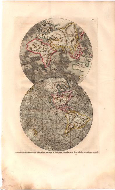
Very unusual world map from a Dutch book on church history published by the Goeree brothers. While not mentioned by Shirley, this map is obviously based on the hemispheres by Thomas Burnet in his Telluris Theoria Sacra of 1681. Thomas Burnet was the first Englishman to attempt a scientific account of the origin of the earth. His popular and controversial treatise focused on the breaking up of "the fountains of the great deep" as the cause of the flood, as described in Genesis 7:11, and it presented a model of the earth's structure with ample stores of water within subterranean chambers. This adaptation presents the hemispheres, one above the other, and slightly overlapping. The earth is shown after the Flood; the continents in outline with accentuated chains of mountains and no place names. Numerous islands are shown throughout the oceans denoting hypothetical lands that existed before the Flood. California is depicted as an island and Australia and New Zealand are partially formed.
References: cf Shirley #507.
Condition: A
Watermarked paper with wide margins and a hint of text transfer from opposing page. There are damp stains in bottom corners, far from image, with some paper weakness in bottom left corner.