Subject: Northern Canada
Period: 1823-28 (dated)
Publication: Narrative of a Second Expedition to the Shores of the Polar Sea
Color: Black & White
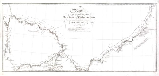
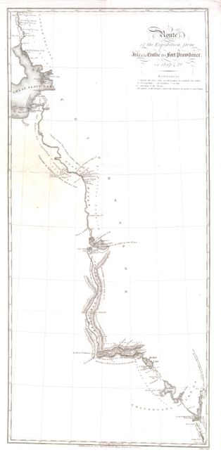
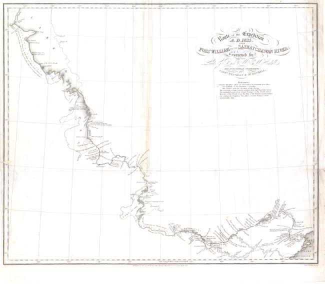
This set of three maps depict the routes of Sir John Franklin's expeditions through Canada to survey the shores of the Polar Sea. Sir John Franklin was a British explorer who joined the Navy in 1801 and fought in numerous battles, including the Battle of Trafalgar in 1805. In 1818 he was charged with leading an expedition over land from Hudson Bay to the mouth of the Coppermine River. On his first attempt he was forced to return home after only six months due to ice pack, but he set sail again in 1819 and was able to completed his journey in 1822. Unfortunately, the expedition was not well supplied, and Franklin lost half of his party due primarily to starvation. Franklin published his account in Narrative of a Journey to the Shores of the Polar Sea. In 1825 Franklin set out on another expedition, this time from Great Slave Lake down the Mackenzie River, and westward along the Arctic shoreline. This expedition was better supplied and more successful than the previous, which Franklin described in his Narrative of a Second Expedition to the Shores of the Polar Sea. Both of Franklin's narratives of his expeditions were published by John Murray. After serving as the Lieutenant-Governor of Van Diemen's Land (Tasmania) from 1836-43, Franklin departed on a fourth and final voyage to the arctic to find a Northwest Passage. Tragically, the ships became trapped in ice and Franklin and all of his crew are believed to have perished.
This set of maps includes three of the six maps that were published in Franklin's account of his "second expedition" (technically his third voyage). Two of the maps depict Franklin's second voyage, which depict his route from York Factory (on the southwestern shore of the Hudson Bay) to Great Slave Lake. The third map depicts the route from Fort William on Lake Superior to the Saskatchewan River (on the northern end of Lake Winnipeg) from Franklin's third voyage. This map was surveyed by Lieutenants George Back and Edward Nicholas Kendall, with astronomical observations by Franklin and Kendall. Each of the maps is highly detailed, with numerous place names, depictions of navigational hazards, direction of the current, and small notes.
A. Route of the Expedition from York Factory to Cumberland House…, engraved by J. Walker, dated 1823 (21.5 x 9.5"). Condition: There are a couple of printer's creases. (B+)
B. Route of the Expedition from Isle a la Crosse to Fort Providence in 1819 & 20, engraved by J. Walker, dated 1823 (9 x 19.8"). Condition: There is minor soiling and an archivally repaired hole south of Slave Lake, with tiny loss of image. Narrow margin at bottom. (B)
C. Route of the Expedition A.D. 1825, from Fort William to the Saskatchawan River…, engraved by J. & C. Walker, dated 1828 (17 x 14"). Condition: There is light soiling, an archivally repaired hole at left with small loss of border, and a number of tiny tears and separations along folds that have also been archivally repaired. (C+)
References:
Condition:
Issued folding, now flattened, with light, extraneous creases. See description for details.