Subject: Reference Books
Period: 1975-2003 (published)
Publication:
Color:
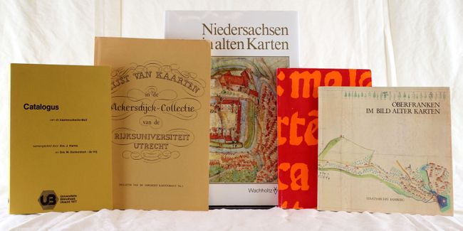
A. Niedersachsen in Alten Karten…, by Karl Wachholtz Verlag Neumunster, published 1985, printed color (9.8" x 13.3"). This German text reference book features antique maps of Lower Saxony, Germany from the 16th to 18th centuries. There are numerous illustrations, most of them in color. Hardbound with red cloth-covered boards and an illustrated dust jacket, 179 pp.
B. Oberfranken im Bild Alter Karten, by Bamberg, Historisches Museum, Reichssaal (Alte Hofhaltung), published 1983, printed color (9" x 8.3"). This German text reference book features antique maps of Upper Franconia, Germany from the 16th to early 19th centuries. There are numerous illustrations, a few in color. Paperback with illustrated dust jacket, 84 pp.
C. Wertvolle Bucher Manuskripte Autographen Druckgraphik Handzeichnungen, by Venator & Hanstein KG, published 2003, printed color (6.8" x 9.5"). This is an auction catalog from April 4-5, 2003, listing 2185 lots ranging from maps, prints, art and autographs. There are numerous illustrations, some in color, and an extensive index at the back by both creator and keyword. A pamphlet with the results from the auction is also included. Paperback, 471 pp.
D. Lijst van Kaarten in de Ackersdijck-Collectie van de Rijksuniversiteit Utrecht, by Bulletin van de Vakgroep Kartografie, Utrecht Geografisch Instituut van de Rijksuniversiteit, published 1975, black & white (8.3" x 11.5"). This Dutch text catalog lists the maps in the Ackersdijck Collection at the Utrecht University (formerly known as Rijksuniversiteit Utrecht). The maps are listed by geography, and an index to the maps is included. Paperback, 221 pp.
E. Catalogus van de Kaartencollectie-Moll, by Universiteits Bibliotheek Utrecht, published 1977, black & white (6.5" x 9.5"). This Dutch text catalog lists the maps in the Moll Collection at Utrecht University. Gerrit Moll was a long-time professor at the University. The maps are listed by geography, and an index to the maps is included. Paperback, 171 pp.
References:
Condition: B+
Books range from very good to near fine with light wear and occasional soiling.