Subject: Asia
Period: 1757 (circa)
Publication:
Color: Hand Color
Size:
37.5 x 22.5 inches
95.3 x 57.2 cm
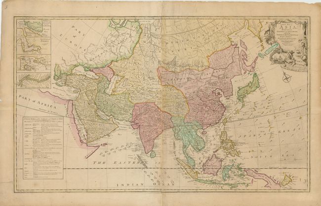
This uncommon, large map of Asia extends west to the eastern Mediterranean and the Red Sea. Sayer gives credit to D'Anville and Robert de Vaugondy for the improvements in cartography. The Korean peninsula is truncated, and Japan with Land of Yezo (Hokkaido) are too large. In the northeast corner are two fictitious islands, Company's Land and Land seen by Juan de Gama, which were supposedly discovered by Jean de Gama. Vitus Bering finally debunked the myth of the islands in his explorations of the area in 1729, but the islands remained on maps for almost 50 years until Cook confirmed Bering's reports. The direction of the trade winds is shown in the seas. Insets of the Dardanelles, the Gulf of Smyrna (Izmir), Bombay (Mumbai), and the Hooghly River detail important centers in the British Empires’ quest to dominate trade with Asia. A detailed table at bottom left outlines the divisions within Asia by the Eight Principal Parts and the European Settlements. The map is adorned with a compass rose and an elaborate title cartouche surrounded by images of the Orient. Printed on two sheets, joined as issued.
References:
Condition: B+
Old color and wide margins with light toning along centerfold, a few minor creases, and one tiny hole. A few short tears in blank margins, and one that enters 2" into map image at right, have been professionally closed on verso with Japanese tissue.