Subject: World & Continents
Period: 1630 (circa)
Publication:
Color: Hand Color
Size:
21.3 x 16 inches
54.1 x 40.6 cm
A superb set of world and continents maps by Willem Blaeu, all with cartes-a-figures borders. These maps were issued separately, and then first used in an atlas in Blaeu's Atlantis Appendix in 1630. These examples have no text on verso, which is extremely rare. Blaeu's atlases published after 1635 had text on the verso, which are more commonly found on the market. This magnificent set includes:
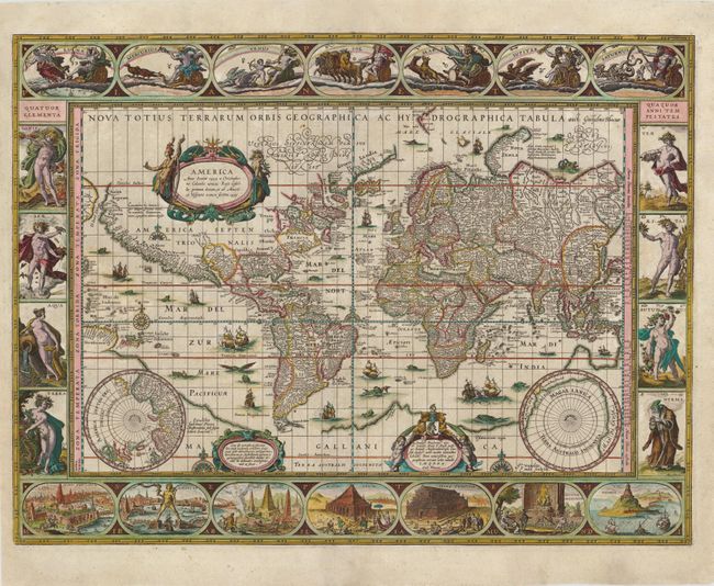
A. Nova Totius Terrarum Orbis Geographica ac Hydrographica Tabula. A magnificent map featuring a carte-a-figures border with allegorical representations of the sun, the moon, the five known planets, the four elements and the four seasons. Along the bottom are vignettes showing the seven wonders of the world: the Hanging Gardens of Babylon, the Colossus straddling the harbor at Rhodes, the Pyramids, the Mausoleum of Halicarnassus at Cairo, the Temple of Diana, the Statue of Jupiter and the lighthouse at Alexandria. Josua van Ende engraved this map, reducing it from Blaeu's 1605 wall map for inclusion in atlases. Petrus Plancius' world map of 1592 was the main source of geographical information. The map is shown on Mercator's projection with a massive Southern Continent attached to New Guinea, with the coastal names of Beach and Psittacorum regio noted from Marco Polo's travel memoirs. North America has the westward bulge characteristic of the time, with the Strait of Anian noted. Korea is shown as an island and Japan is in a kite-like shape. The map itself is richly decorated with cartouches, sea battles, monsters and compass roses. Fourth state with Tierra del Fuego shown as an island and the date omitted from the lower cartouche on the right. Ref: Goss (Blaeu) #1; Shirley #255. Cond: Centerfold separations and tiny tears near centerfold have been expertly repaired. (A)
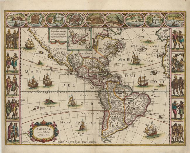
B. Americae Nova Tabula. This stunning carte-a-figures map is a superb example of the fine art of decorative cartography and a seventeenth-century European view of the New World. The coastal outlines generally follow Ortelius and Wytfliet with nomenclature from a variety of explorers and colonists. Panels at sides, each with five portraits of the native inhabitants, were taken from John White (Virginia), Hans Staden (Brazil) and other early explorers' accounts. Across the top are nine town plans including Havana, St. Domingo, Cartegena, Mexico City, Cusco, Potosi, I. la Mocha in Chile, Rio de Janeiro and Olinda in Brazil. This is one of the few maps of the Americas by this famous Dutch cartographer. The map itself is similar to Blaeu's wall map of 1608 with the additional discoveries of Henry Hudson in North America, and Tierra del Fuego with Le Maire Strait. This is the third state of the plate with the imprint changed to Auct: Guiljelmo Blaeuw. Examples without text on verso are particularly rare. Ref: Burden #189; Goss (Blaeu) p. 156; Tooley (Amer) p. 297. Cond: Right and left-hand margins have been extended to better accommodate framing, and two short tears that enter 3/8" into map image at right and left have been expertly repaired. There is a minute hole west of Peru that has also been expertly repaired. Manuscript page number at top right. (A)
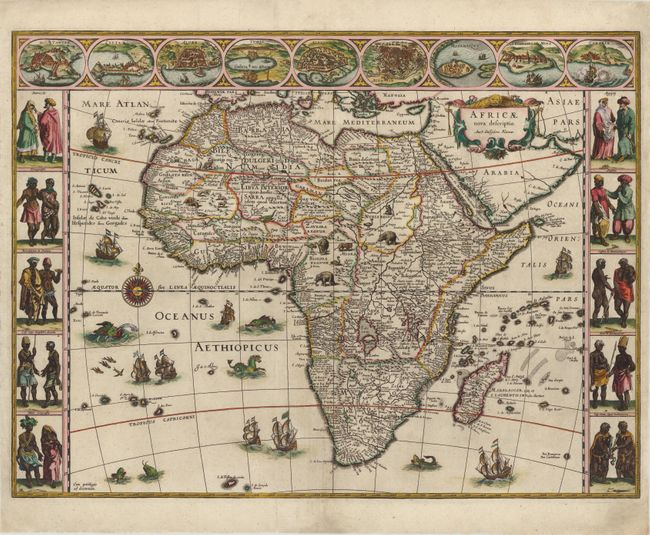
C. Africae Nova Descriptio. This is one of the most decorative seventeenth century maps of the African continent and a superb example of the Dutch carte-a-figures style. The map is surrounded on three sides with vignettes of native peoples and nine principal cities. The Nile is shown according to Ptolemy with its sources arising in the lakes Zaire and Zaflan, the fictitious Lake Sachaf of Laurent Fries appears, as well as the R. de Spirito Santo. The map is further embellished with numerous ships, sea monsters (including a great seahorse), a compass rose and exotic animals wandering all over the continent. This is the second state of the map with the imprint changed to Auct: Guiljelmo Blaeuw. Ref: Betz #57.2; Norwich #32. Cond: A centerfold separation that enters 5" into map image at bottom and a tiny tear west of Monomotapa have both been professionally repaired. (B+)
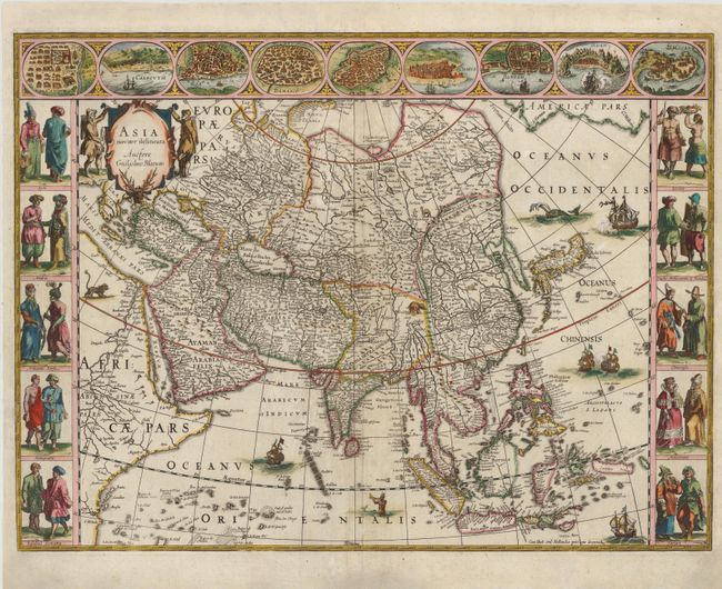
D. Asia Noviter Delineata…. This is one of the most famous 17th century maps of the continent of Asia. It is surrounded in a beautiful carte-a-figures border and is richly ornamented with animals, sea monsters and sailing ships. The eastern coastline of Asia is severely truncated, Korea is shown as an island, and Japan is depicted on the Ortelius-Teixeira model. The Indian subcontinent is too narrow and the islands of Indonesia are very sketchy. A large island labeled Ceiram probably represents the western part of New Guinea. In the interior, the Caspian Sea is oriented on an east-west axis and there are several large erroneous lakes in China including the mythical Chiamay Lacus. The frieze across the top features vignettes of the cities of Candy, Calecut, Goa, Damascus, Jerusalem, Hormuz, Banten, Aden and Macao. The inclusion of Banten reflects the emergence of the Dutch as a major commercial power in the East Indies. The side panels flanking the map depict costumed figures of the various Asian peoples. Ref: Walter #25; Yeo #24. Cond: Short centerfold separations and a tear that enters 1" into map image at bottom have been professionally repaired. (B+)
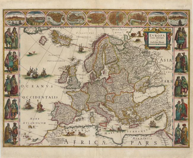
E. Europa Recens Descripta. This classic map of Europe is done in the carte-de-figures style with vignettes on three sides. The upper frieze has nine bird's-eye views of Amsterdam, Prague, Constantinople, Venice, Rome, Paris, London, Toledo and Lisbon. The side borders contain the costumes of the noblemen and women of ten European nations. The map is embellished with sailing ships, sea monsters, bears and Neptune riding a dolphin and holding his trident. A beautiful map produced at the height of the Golden Age of Dutch mapmaking. Ref: Goss (Blaeu) #4, p.30. Cond: Several centerfold separations and a tear that just enters map border at bottom have been professionally repaired. (B+)
References: See description.
Condition:
Attractive color with some small tears and chips in blank margins that have been expertly repaired. See description for additional details.