Subject: Reference Books
Period: 1922-82 (published)
Publication:
Color:
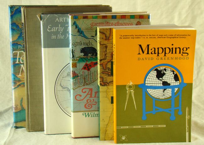
A) The History of Topographical Maps: Symbols, Pictures and Surveys by P.D.A. Harvey, published 1980, printed color, (7.5 x 10"). From Ancient Egypt, medieval Europe to Colonial America, this book covers the evolution of topographical maps. 199 pp. with 116 illustrations, 10 of which are in color. Hardbound in blue cloth boards and illustrated paper covers with gilt stamp on cover and gilt title on spine. (A+)
B) Early Thematic Mapping in the History of Cartography by Arthur H. Robinson, published 1982, printed color, (7 x 10"). This work is the first to trace thematic mapping through its maturity in the mid-nineteenth century. 266 pp. with numerous illustrations, some of which are in color. Hardbound in blue cloth boards and paper covers. Condition - book is fine and the paper covers show some wear and chipping along the edges. (A)
C) Mapping by David Greenhood, published 1964, black & white, (6 x 9"). 289 pp. with illustrations and includes an excellent section on map projections. Paperbound. (A)
D) Animals & Maps by Wilma George, published 1969, black & white, (6.3 x 9.8"). George documents how cartographers actually knew much about the animals on the continents and that the creatures depicted were not mythical at all. 235 pp. with illustrations. Hardbound in red paper boards with illustrated paper covers and dust jacket. Condition - book is fine with some minor wear to the dust jacket. (A)
E) Maps & Civilization: Cartography in Culture and Society by Norman J.W. Thrower, published 1996, black & white, (6 x 9"). 326 pp. with illustrations. Paperback. (A+)
F) The Face of the Earth as Seen from the Air: A Study in the Application of Airplane Photography to Geography by Willis T. Lee, published 1922, black & white, (7 x 10"). A look at aerial photography in its infancy, illustrated with 82 aerial photographs and maps. Most of the aerial photos were taken by the United States Army Air Service and the United States Navy Air Service. 110 pp. Hardbound in gray cloth boards. Condition - the rear cover has a small water stain and the covers are somewhat worn. (B+)
References:
Condition:
See descriptions.