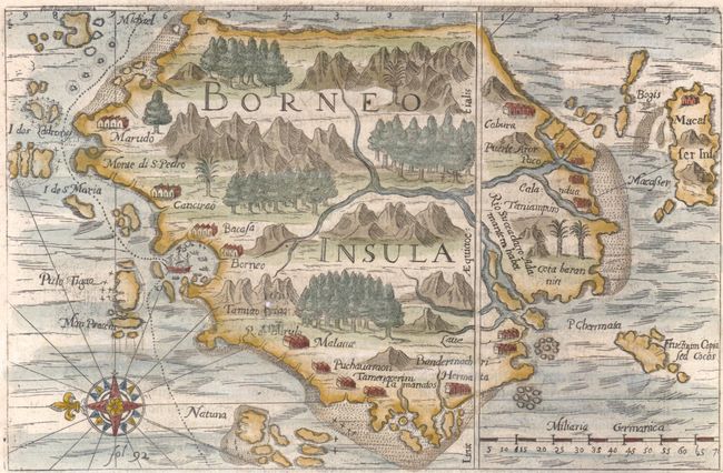
Subject: Borneo
Period: 1631 (circa)
Publication: Petits Voyages
Color: Hand Color
Size:
8.5 x 5.5 inches
21.6 x 14 cm
This copper engraving is from a remarkable series of publications, illustrating voyages of discovery and travels of exploration to various parts of the world. The project was begun by Theodore de Bry of Frankfurt, in 1590 and was to continue for another 54 years. They became known collectively as the Grands Voyages (to America and the West Indies) and the Petits Voyages (to the Orient and the East Indies). De Bry died after the first six parts of the Grands Voyages were completed. The project was completed initially by his widow and two sons, Johann Theodore de Bry and Johann Israel de Bry, then by Johann Theodore's son-in-law, Matthaus Merian, in 1624.
This rare early map of Borneo is oriented with east at top. It illustrates the voyage of Olivier van Noort, the first Dutchman to circumnavigate the world. His ship is depicted in the large Brunei Bay surrounded by native boats. Van Noort’s description of the island is one of the earliest descriptions of this important island. A few towns are shown along the coastline and the interior is filled with mountains, forests and a large river. The east coast is a hypothetical coastline, as it was still undiscovered by European explorers. The map is adorned with a compass rose, and is on a full sheet of German text, measuring 9 x 13.5".
References: Suarez, T. (SE Asia) p.185, fig.102.
Condition: B+
A few minute holes near Malana due to a paper flaw, and some marginal soiling.