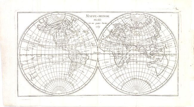
Subject: World
Period: 1759 (dated)
Publication: Dictionnaire Geographique Portatif
Color: Black & White
Size:
11.8 x 6.3 inches
30 x 16 cm
This double-hemisphere map is particularly interesting for its presentation of a variety of the Northwest Passage theories prevalent at the end of the eighteenth century. None of the waterways quite form a complete passage, but a number of the fictional lakes from Admiral de Fonte's infamous expedition are depicted and there is a huge Sea of the West. The coastline of northwest North America is still uncertain, with Alaska depicted as a large island with a note indicating its discovery by the Russians. Boston, New Orleans, Quebec and Mexico City are the only cities named in North America. Only the eastern coastline of New Zealand is depicted, and Australia is shown in a preliminary shape that incorporates Tasmania and New Guinea and truncates the eastern coastline. This map was included in Dictionnaire Géographique Portatif from the English edition by Laurence Echard and translated into French by "Vosgien" (J. B. Ladvocat).
References: McGuirk #51.
Condition: A
Issued folding.