Subject: Yosemite, California
Period: 1883 (circa)
Publication:
Color: Printed Color
Size:
21.3 x 14.5 inches
54.1 x 36.8 cm
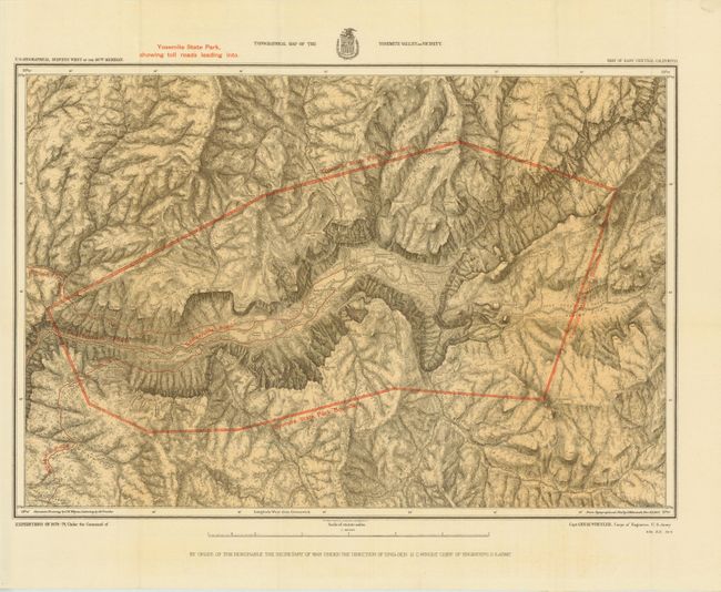
The 1870s was a period of intense effort, by such prominent people as Clarence King, Ferdinand Hayden, and John Wesley Powell, to advance the geographical knowledge of the West. These various surveys presented a threat to the Army's supremacy in the field of mapping and to the related appropriations from Congress. As a result of these pressures, the Army Corp of Engineers developed a plan to systematically survey the entire West to be called the U.S. Geographical Surveys West of the One Hundredth Meridian. The region was divided up into 95 rectangles, with atlas sheets to be prepared for each, comprising an area 2°45' of longitude and 1°40' of latitude on a scale of eight miles to the inch. Lieutenant George Wheeler was chosen to head this immense project. Surveys were conducted each summer from 1872 to 1878, after which Congress cut off appropriations for field work; thus the survey was not completed as originally envisioned. Wheeler published annual reports from 1873 to 1884, as well as the final Geographical Report published in 1889. The maps from this report are a valuable document of the record of Western exploration.
This fine map details the early development of the Yosemite valley after being designated a state park in 1864. The map is a product of Capt. G.M. Wheeler's Expeditions of 1878-79 with the U.S. Geographic Surveys West of the 100th Meridian, and depicts the state park boundaries and the toll roads leading to the park. Early camp facilities, trails, Indian settlements, and salient geographic features are also identified in considerable detail. The skillful rendering of the topography creates a remarkably strong graphic image of this picturesque valley. Mountain drawings by J.E. Weyss, with lettering by M. Franke, from the topographical plat by Lt. Macomb, Nov. 30, 1883.
References:
Condition: A
There is one tiny short split at a fold intersection, else fine.