Subject: Western United States
Period: 1853-54 (dated)
Publication: Railroad Surveys
Color: Hand Color
During the 1850s, the U.S. government sponsored an extensive series of expeditions designed to gather information on the vast new territories that had been acquired in western North America. The discovery of gold in California further stimulated westward traffic and heightened the need for a faster and more convenient way to bring the far-flung parts of the country together. In 1853 Congress commissioned the Army's Topographic Bureau to conduct a series of surveys to find a suitable route for a transcontinental railroad. There were six major expeditions; five of them covered the area between the Great Plains and west coast, and the sixth explored the coastal states of California and Oregon. All of these expeditions were accompanied by naturalists and artists to document the landscape, flora and fauna along the route.
The reports, maps and lithographs were published in the 13 volume report "Explorations and Surveys to ascertain the most practicable and economical route for a Railroad from the Mississippi river to the Pacific Ocean."
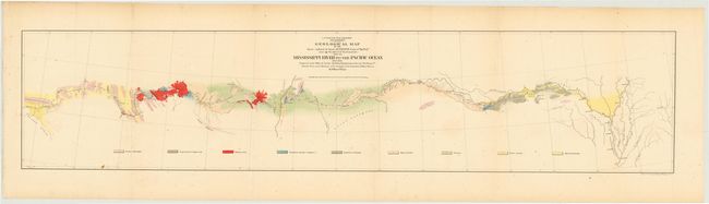
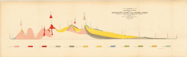
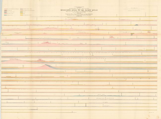
This nice set of three maps shows geological sections from Memphis to Los Angeles, surveyed by Jules Marcou and W.P. Blake for the Pacific Railroad Surveys. The geology of each sheet is delineated and color-coded with a legend naming numerous geological units.
The first sheet (8 x 36.5") shows a few cities located along the way; Helena, Napoleon, Vicksburg, Pine Bluff, Little Rock, Fort Smith, San Antonio, Fort Defiance and Needles. The route cuts across the Llano Estacado, north of the Wichita Mountains, and along the edge of the Mogollon Rim, here named the Sierra Mogoyon. The second sheet (11 x 36") and third sheet (27 x 38") are profile views, the first being an overview and the second a continuous detailed profile, displaying the geologic formations in relation to elevation.
References:
Condition: B
Each of the sheets has some slight extraneous creasing. The largest sheet has a 3 x 9" tear in the left side of the image that has been repaired on verso with archival tape.