Subject: New York, United States & Quebec, Canada
Period: 1759-60 (published)
Publication:
Color: Black & White
Size:
4.5 x 7.5 inches
11.4 x 19.1 cm
This set of maps relate to the Battles at Ticonderoga and Quebec at the end of the French and Indian War. On July 26-27, 1759, General Sir Jeffrey Amherst led a British military force to high ground overlooking Fort Ticonderoga, which was defended by Frenchmen under the command of Brigadier General François-Charles de Bourlamaque. As the French were grossly out-manned by the British, de Bourlamaque decided to withdraw his forces rather than defend the fort. In their retreat, the French forces attempted to blow up the fort, but succeeded only in destroying the fort's powder magazine. After the fall of Quebec on September 13, Montreal was the sole remaining French power center in Canada. General Amherst began a three-pronged offensive converging on Montreal the following spring. When Vaudreuil de Cavagnal surrendered on September 8, 1760, this ended the last major campaign of the French and Indian War.
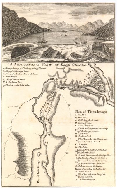
A. Plan of Ticonderoga [on sheet with] A Perspective View of Lake George, Universal Magazine, (6.3" x 10.3"). This plan of the area surrounding Fort Ticonderoga includes a lettered legend to key locations of the British army's movements. Above the plan is a view of Lake George showing the fort and munitions piles in the foreground, with two gunboats anchored near the shore. The map is accompanied by the Universal Magazine article describing the battle, as told by British Captain-Lieutenant H. Skinner. Ref: Jolly #UNIV-84; Phillips (M) p.293. Condition: Trimmed to neatlines with faint foxing. (B+)
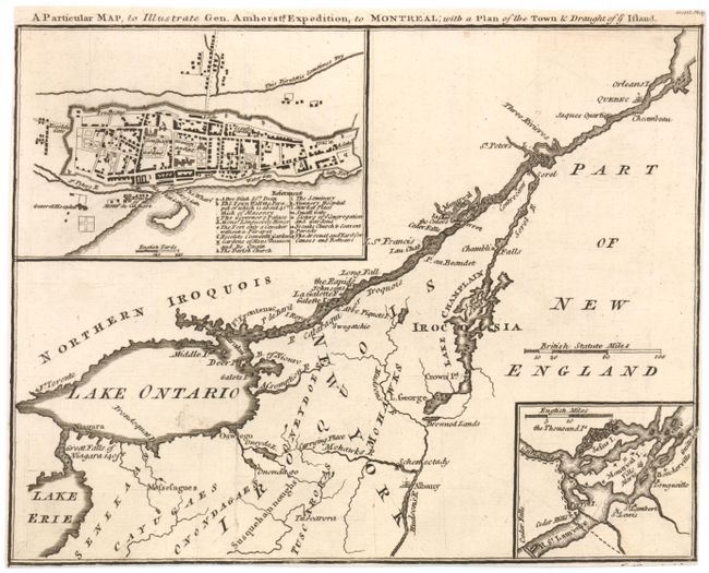
B. A Particular Map, to Illustrate Gen. Amhersts, Expedition, to Montreal; with a Plan of the Town & Draught of ye Island, Gentleman's Magazine, (9" x 7"). This map shows the St. Lawrence River from Quebec City to the Great Falls of Niagara 140 ft and east to include the Hudson River, Albany and Lake Champlain. Details include several forts, Drowned Lands, and Indian tribes. An inset at lower right shows the environs of Montreal Island. At upper left, a plan of the walled city of Montreal portrays individual buildings and has an index of 16 important features including the Arsenal, hospital, the Governor's Palace, and the gardens of Mons Beausou and de Quain. Engraved by J. Gibson. Ref: Jolly #GENT-145. Condition: Trimmed to neatlines with a few light creases and one insignificant spot. (B+)
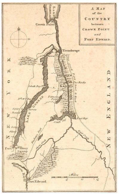
C. A Map of the Country between Crown Point and Fort Edward, Gentleman's Magazine, (4.5" x 7.5"). This map depicts the area surrounding Lake George, along the northeastern border of New York state, extending up to Lake Champlain. Several forts are shown, including Fort Ticonderoga, along with a very good path east & west next to the drown'd lands. One of the trails is labeled Dieskau's Path referring to the route taken by French and Indian forces under the command of German Baron Ludwig August Dieskau and British and Colonial troops under Sir William Johnson that resulted in a series of skirmishes and engagements known collectively as The Battle of Lake George. This battle was the first significant win against the French forces by British Provincials. Ref: Jolly #GENT-129. Condition: Trimmed to neatlines with faint foxing. (B+)
References:
Condition:
See description.